River Roots is Susquehanna NHA’s blog series featuring history from York and Lancaster Counties that showcases the Susquehanna River’s historic, cultural, and natural resource contributions to our nation’s heritage.
Each year, an annual event makes its way to the lower Susquehanna River. Those who live and work along the river know about the event, and many of those local folks have a story about it. It gets a lot of attention and questions from visitors. We do not know when this event will happen, how big it will be, or how long it will stay. Each summer, we are all waiting for “The hatch”.
The hatch is not a budget horror film, but rather what we call the emergence of thousands, even millions, of mayflies. Actually, several species of mayflies hatch all along the river at different times. But, when conditions are just right, swarms of mayflies appear without warning, overnight. They disrupt our peaceful summer evenings and leave us with a big mess in the morning. This unexpected event can be the bane of outdoor weddings and events. The swarms can even cause traffic problems. But mayfly hatches are important events, and their growing size is a sign of the river’s improving health. It can be both thrilling and frustrating to witness a large mayfly hatch over the Susquehanna.
What Are Mayflies?
The day after a hatch, thousands of dead mayflies lie piled around lamp posts and streetlights. They cover sidewalks and parking lots like snow. Out-of-town visitors encountering them for the first time usually have one question: what are those things?
Mayflies are aquatic insects that belong to the order Ephemeroptera, which means “short-lived”. They are also known as shadflies, fishflies, or up-winged flies. They are ancient insects that have lived on this planet for over 350 million years. They even lived while dinosaurs were here. There are more than 600 species of mayfly in the United States and over 3,000 worldwide. In Pennsylvania, there are at least 175 different species. Mayflies can vary in size, but they typically grow anywhere from 0.25 to 1.1 inches. The largest species of mayfly in the world is the Tisza Mayfly, found in Eastern Europe. It measures 4.7 inches from head to tail. The Tisza Mayfly hatch has become a tourist attraction known as the “Blooming of the Tisza.”
Mayflies spend most of their lives underwater. They begin as eggs and then hatch into nymphs (the first hatch of a mayfly’s life). As a nymph, a mayfly can live underwater anywhere from 2 weeks to 2 years, depending on the species. When the nymphs finish growing, they make their way to the surface and the hatch begins.
The Mayfly Hatch
Mayflies emerge at different times, depending on the species, weather, and water conditions. They could “hatch” from their nymph form in May… but it also happens in June, July, and even August. That’s because different mayflies, caddisflies, stoneflies, and duns hatch from April through September. Some species hatch several times a year if the conditions are right.
First, the nymphs emerge from the water by swimming to the surface or climbing out on rocks to the banks. Then, they shed their husk and become duns (subimagos). The duns float along the surface until their wings are dry enough to take flight. The duns fly into the bushes and trees along the riverbank, where they shed their skin and become complete adults, also known as spinners.
Many species of mayflies synchronize their emergence, increasing the likelihood of reproduction. Male mayflies spin and dance to attract a mate, usually beginning around dusk. The females join the dance and the mayflies swarm and mate in the air. The female then immediately lays her eggs in the water. After laying her eggs, she dies. In some species of mayfly, the eggs stay in the female’s body, floating with her to her underwater grave. Adult mayflies do not have mouths, since they do not eat during their few fleeting hours of adulthood
Hatches Along the Susquehanna
These large hatches are a good sign for the region. Mayflies and other bugs are so small that even small amounts of pollution can kill them. Mayflies are particularly sensitive. Even modest levels of water pollution can kill up to 80 percent of their eggs, so they are usually only found at minimally-polluted sites. Because they live in a wide variety of habitats and are so sensitive to pollution, mayflies are valuable water quality indicators.
As water quality improves, hatches will get bigger and more species of mayflies may also appear. Whiteflies hatch in large numbers in this region. Hexagenia bilineata, large dark mayflies whose dense swarms show up on weather radars, also hatch along the Susquehanna River.
Mayflies are common fish food because so many adults emerge from the stream at the same time. Fly fishers often use flies made to look like mayflies. During hatching season, fishermen and fisherwomen everywhere use artfully made flies that resemble these glorious insects. Mayflies are an extremely popular entrée for several types of fish, including trout. The nymphs are also a source of food for fish, birds, frogs, and other predatory insects.
Mayfly Mayhem of June 2015
One hatch here along this part of the Susquehanna River made international news in 2015. A swarm took to the lights on the Veteran’s Memorial Bridge on June 13, 2015, and created blizzard-like conditions. Several inches of dead mayflies piled up on the bridge, causing slick driving conditions and three motorcycle crashes. The bridge closed, and snowplows were even used in the cleanup. The bridge closed again briefly the next night due to another swarm.
Now, Columbia Borough turns off the bridge’s lights for a few weeks every summer to avoid another possible mayfly calamity. The dark bridge usually captures the interest of people unfamiliar with our river who wonder why the lights are out.
Those of us who love and respect the river, who work hard to make it a clean and healthy body of water, know that these mayfly swarms are a welcome sign that the river is improving. Like the mayfly’s lifespan, the hatch is a fleeting time full of stories, photos, and a little bit of mayhem. As the weather starts to warm up and we spend our days outside along the river, we all start to look and wait for our upcoming annual event: the hatch.
Learn More
June 8, 2022: Follow the Hatch—Aquatic Insects in Lancaster County’s Streams and Rivers 6:00 PM – 7:30 PM at Columbia Crossing. Join Dr. John Jackson of Stroud Water Research Center and Keith Williams of Lancaster Conservancy for a deep dive into the world of mayflies, stoneflies, caddisflies and the many other tiny creatures that call our streams home.
River Roots is Susquehanna NHA’s blog series featuring history from York and Lancaster Counties that showcases the Susquehanna River’s historic, cultural, and natural resource contributions to our nation’s heritage.
What is a shifter, exactly? In the Susquehanna National Heritage Area, it’s a railroad locomotive and a sandwich! But, it’s not just any sandwich. It’s a sandwich with local roots, almost exclusively served along the Susquehanna River in Columbia and Marietta.
Local accounts trace the origins of this sandwich back to the 1910s in Columbia. In that era, the railroad yard by the river was bustling with activity. An army of skilled and unskilled workers labored in the switching yard near the roundhouse. A roundhouse is large circular or semicircular building around turntabled used for servicing locomotives. Mechanics maintained locomotives, workers rushed to clean up after derailments, and conductors used “shifters” to move railroad cars from drop-off to pick-up points.
PRR roundhouse in Columbia. Courtesy of Columbia Historic Preservation Society
A “shifter” (also known as a “switcher”) is a small railroad locomotive used for maneuvering railroad cars inside a rail yard. Shifters are not intended for moving trains over long distances. They are for assembling train cars for another locomotive to take over. The typical shifter is low-powered but has a high starting tractive force for getting heavy cars rolling quickly. Switchers produce high torque but move slowly and have small diameter driving wheels. Shifters are to trains are what tugboats are to boats.
PRR 0-6-0 wood-burning shifter engine at the foot of Front & Locust Street in Columbia during the 1870’s. Courtesy of Columbia Historic Preservation Society
Switching was hard work. Shifter engines wore out quickly from constant collisions with cars and frequent starts and stops. Switcher locomotives needed water and coal or wood to operate. Some had a tank for water and others had a car called a “tender” that carried their fuel.
The hustle and bustle of downtown Columbia centered around the river and railroad industry. The low vibrations of trains riding the rails, the loud train whistles, and the smell of heat filled the air. Working in the rail yard was hard work, and the men worked up a mean appetite. Columbia’s restaurants, bars, and hotels all created hearty meals that workers could dig into as soon as they clocked out. One of those meals was the monster of a ham and cheese sandwich that we now call the Shifter.
Columbia Café, 307 Locust St. Columbia, Pa circa early 1900’s. Courtesy of Columbia Historic Preservation Society
There are a few stories in Columbia about who started serving the Shifter sandwich first. One story is that it was first started by the Lutz family at their hotel on Front Street in the 1930s. The Olena family also claims that they served Shifters in Columbia Cafe in the 1910s. Later, the Rising Sun Hotel claimed it, since they included the sandwich with an overnight stay. The Rising Sun may have been the first one to put the ingredients in the order we still use today. Although we can’t sort out all the gossip about its origin, we are going to share here the story from descendants of the Columbia Café family.
The “Shifter Club” was made up of a group of engineers and conductors who worked the switching yard. The Shifter Club met daily at the Columbia Café on Locust Street for lunch. Every time a new member joined the team, they had to buy lunch for the rest of the crew. As the economy worsened in the early 1900s, the tradition began to get too expensive to uphold. The owner of Columbia Café, Tuffield Olena, and his friend Benny Potts decided to come up with an affordable meal to keep the Shifter Club coming to the café. Between 1915 and 1920, the Columbia Café’s kitchen created a simple ham and cheese sandwich. They informally called it the “Shifter” after the group of guys for which they created it. However, the Columbia Café didn’t list the Shifter on the café menu because they only made it for the Shifter Club. The Columbia Café didn’t add the now-iconic sandwich to their menu until they moved to 4th & Locust Street in 1920.
Columbia Café Interior at 4th & Locust St. location. Courtesy of Columbia Historic Preservation Society
Feeding railroad workers was big business in Columbia. Railroad bosses often ordered a gallon of coffee, a gallon of soup, and a pile of sandwiches at three separate hotels. Columbia hotels were the top choice for lodging by railroad workers because the owners often included meals in the price. By the 1930s, many local eateries recreated and offered the Shifter to Columbia’s railroad workers. The Rising Sun Hotel and the Lutz/Lower Hotel both served up Shifter-style sandwiches to their guests. Both hotels wrapped the sandwiches to keep the food clean when workers ate them with one hand as they worked.
The basic Shifter wasn’t exactly nutritious, so restaurants added lettuce, tomatoes, and pickles. Local hotels often served Shifters at company-provided lunches for shift workers, so the name stuck around even after the railroads left Columbia.
The modern Shifter has a very specific construction. It starts with a slice of white bread, then a layer of mayonnaise, lettuce, and tomato slices. Next come two slices of Swiss cheese, two ounces of ham and dill pickles, and then another slice of white bread. If your sandwich isn’t constructed in that order, it is not a Shifter. Some people accept a few variations, like turkey instead of ham or sweet pickles instead of dill. Still, the Shifter remains mostly unchanged over the 100 years since it became a local favorite!
Learn More
Columbia Railroad Day is Saturday, May 7, 2022, from 11 am – 4 pm at the Columbia River Park! This year, it’s all about the Pennsylvania Railroad’s history in Columbia. Enjoy “HO” and “O” gauge model trains at the Columbia Historic Preservation Society. Ride a “speeder” or small gas-powered unit on the spur line that runs through Columbia. Take a historic tour on a vintage trolley or attend lectures at Columbia Crossing. Enjoy the Shifter Showdown, a variety of vendors, and food in the River Park.
Want to try Columbia, Pa’s most famous fare? Stop for lunch during your next visit and order an authentic shifter from Rose’s Deli & More or Hinkle’s Restaurant!
River Roots is Susquehanna NHA’s blog series featuring history from York and Lancaster Counties that showcases the Susquehanna River’s historic, cultural, and natural resource contributions to our nation’s heritage.
The Susquehanna River has never succeeded as a commercial waterway because of its many rocks and waterfalls. Many people tried throughout history, but the Lower Susquehanna remained largely untamed until the early 20th century. The power-producing rapids and the 1,180 feet of elevation change between Cooperstown and the Chesapeake Bay made the Susquehanna ideal for hydroelectricity. Dams harnessed the power of the river. Today, there are four dams in the 55 miles of river between Harrisburg and the Chesapeake Bay.
Hydropower is one of the oldest and most available sources of renewable energy. People all over the world have used rivers to power mills since Ancient Rome. Today, the natural flow of moving water power hydroelectric power plants, which produce electricity. The most common type of hydroelectric power plant is an impoundment facility. An impoundment facility uses a dam to store river water in a reservoir. When the water is released from the reservoir flows through a turbine, spinning it, the turbine activates a generator to produce electricity.
Reservoirs are also used as recreation areas for activities like boating, fishing, and other water sports. During droughts or extended periods when water levels are very low, more water is released from the reservoir so farmers can water their crops and homes and businesses can function normally. They are also used for flood control.
Power of the River: Dams on the Lower Susquehanna River
The Lower Susquehanna River is unique because it has a higher fall rate, or elevation change, than the rest of the river. Most rivers have the greatest flow and fall near their source, but the Susquehanna is so old and meanders so far that its fall is greatest in the last 55 miles. Those miles of the river hug York and Lancaster Counties of Pennsylvania and Hartford and Cecil Counties in Maryland. Here, we’ll take a deeper dive into the Pennsylvania hydroelectric plants.
York Haven Hydro Station
Built in 1904
Built/Owned by York Haven Power Company
Current Owners Eagle Creek Renewable Energy Produces 135,485 megawatts, with 13 horizontal Francis turbines, 4 vertical Kaplan turbines, and 3 vertical propeller units
Reservoir Lake Frederick
York Haven Dam is a low head, run-of-the river dam. It was the first hydroelectric plant on the lower Susquehanna River. Located about 12 miles south of Harrisburg where the river drops 19 feet in 1⁄4 mile, the dam follows an existing rock ledge causing it to cross the river at an angle. When the station was built by the York Haven Power Company in 1904, it was one of the largest in the world and is recognized as one of the oldest hydroelectric projects in America. The facility produces 135,485 megawatts with 13 horizontal Francis turbines, 4 vertical Kaplan turbines, and 3 vertical propeller units. The plant is listed as a National Historic Mechanical Engineering Landmark for using one of the first Kaplan turbines installed in the United States.
Lake Frederick Formed by damming the Susquehanna River at York Haven, the 2-1/2-mile Lake Fredrick stretches in the shadow of TMI’s cooling towers providing a unique recreation space. Lake Frederick holds Islands ranging in size from 200ft to 3 miles in length providing spectacular aquatic habitat for native species to thrive and attracts many anglers. Public angling access is located on a walkway along the face of the powerhouse at the York Haven Power Plant Recreation Area below the dam.
Falmouth Potholes & Sculptured Rock
Rivers are a major agent of erosion, shaping landscapes over time with their power. It’s not surprising to find changes in rocks in the riverbed wherever you have a waterfall or otherwise rapid movement in the water. Discovered during extremely low water, this otherworldly landscape is one of the most expansive pothole fields uncovered in the United States. The rocks at the foot of Conewago Falls range in size and display various smooth, curvaceous shapes that captivate visitors.
Safe Harbor Hydroelectric Station
Built in 1931
Built/Owned by Pennsylvania Power & Light Company and Baltimore Gas & Electric Company Current Owners Brookfield Renewable Energy Partners
Produces 417 megawatts with a 12-unit hydro generator powerhouse Reservoir Clarke Lake (Lake Clarke)
Safe Harbor Dam was the last of three hydroelectric dams built on the Susquehanna, located just above the confluence of the Conestoga River with the Susquehanna, about 7 miles south of Washington Boro.
The station was built by the Pennsylvania Power & Light Company and Baltimore Gas & Electric Company in 1931 and received a capacity increase in the 1980’s. The concrete gravity dam that is 4,869ft long and 75ft high with a total length of 5,000 ft stretching shore to shore. It outputs 10 million kilowatts of energy with the 12-unit hydro generator powerhouse that generates 265,000 horsepower.
Lake Clarke
Behind the dam is 7,360-acre Lake Clark, a popular boating and recreation area on the Susquehanna River. The Lake Clarke portion of river marks the beginning of the Susquehanna Gorge formation, a deep canyon-like gorge carved into the ancient rocks where the river is squeezed through the quarter mile gorge while dropping sharply, roughly 6 feet per mile.
Within Lake Clarke you will find the Conejohela Flats, an Audubon important bird area. The Conejohela Flats are part of a network of key stopover sites, locations that offer respite for migratory birds, along the Atlantic Flyway that draw large volumes and varieties migrating birds through the Susquehanna River corridor biannually. Because the creation of Lake Clarke shrank the flats, the water levels are controlled and regulated preserve the habitat from April through October. Safe Harbor also manages more than 2,300 acres of land in the area for soil, water, and wildlife habitat preservation.
Holtwood Hydroelectric Plant (McCalls Ferry Dam)
Built in between 1905 and 1910
Built/Owned by Pennsylvania Water & Power Company Current Owner Brookfield Renewable Energy Partners
Produces 252 megawatts with 14 turbine driven generators
Reservoir Lake Aldred
Holtwood Dam is the second oldest of three dams built across the lower Susquehanna River in Pennsylvania. Located about 5 miles south of Pequea, it’s the southernmost dam on the river before it crosses the Mason-Dixon Line into Maryland. Spanning the river 2,932 ft, Holtwood was the second longest dam in the U.S. and the third longest in the world when it was built. Originally constructed as the McCalls Ferry Dam in 1905 by the McCall’s Ferry Power Company until it was reorganized as the Pennsylvania Water and Power Company and the plant was renamed Holtwood in honor of two company executives and opened in 1910. The dam consists of a main concrete dam, which is mostly one continuous spillway, with a powerhouse at the eastern end. The water level is raised by wooden flash boards and inflatable dam sections. It produces 252 megawatts of power using 14 turbine driven generators.
Lake Aldred The 2,400-acre Lake Aldred is popular recreation area for boating but hosts a maze of rocky islands rising abruptly from the water. Weise Island, in the middle of the Susquehanna River just north of Pequea Creek, is the home of the Lake Aldred Wakeboard & Ski Club. The Lake Aldred portion of the river runs through the lower section of the Susquehanna Gorge formation, high wooded hills and rocky outcroppings rising over 200 ft provide habitat for native wildlife.
An area below the dam called, the Holtwood Whitewater Park, utilizes scheduled whitewater releases from the dam when conditions permit. The large, extremely fast wave and subsequent smaller waves are popular with thrill seeking whitewater kayakers of appropriate skill.
Working together to restore the Susquehanna River
Dredging and Pollution
Since their construction, the reservoirs behind these three dams along the lower Susquehanna River have historically trapped a portion of pollution from the Susquehanna River, and the nutrients that are often attached, reducing the amount the Chesapeake Bay. Although, a recent assessment indicates that the reservoirs are reaching their limit to effectively trap the sediment.
The impounded waters of Lake Aldred and Lake Clarke were originally dredged for anthracite coal silt that washed downstream from Pennsylvania’s Coal Region. Mining upstream reduced the availability of coal silt, and environmental laws made the dredging impractical by 1972, so coal was brought in using trains.
Fish Ladder/Lift
A fish lift or fish ladder is a waterway constructed on or around a natural or artificial obstruction to provide a passageway for fish and other aquatic species. The construction allows a seamless migration despite obstructions like dams, culverts, and waterfalls, which otherwise would have affected their migration and survival. Since 2017 York Haven has used a vertical slot fish ladder, which enables fish to pass over the fourth dam by swimming and leaping up a series of short steps and over the dam, along with a channel system at Three Mile Island, while the other dams use fish lifts.
Operation of the Safe Harbor Fish Lift began in 2016. The fish lift has three entrances where fish are captured in the lift are transferred into the trough that allows them to pass into Lake Clarke. The western end of the Holtwood dam has the original and ineffective fish ladder. It was replaced by a fish lift that was damaged by heavy rain and rapid snowmelt in 1996. The new fish lift was completed and has continued lifting American shad and other migratory fish species since 1997. Despite these efforts, the ladders and lifts show only limited success since fish still must find their way through passages and then pass-through multiple dams.
Conclusion
Today, dams block natural movement of aquatic wildlife, hold sediment at each of the four hydroelectric dams on the lower Susquehanna River. They also provide recreational spaces that visitors flock to annually.
Dams are a controversial environmental topic. They store water, provide renewable energy, and prevent floods. Unfortunately, they also cause a wide range of environmental issues. Dams can disrupt sediment flow, causing sediment to accumulate within the reservoir (impairing reservoir operation and decreasing storage) and depriving downstream of sediment essential to maintain channel and support the riparian ecosystem. Upriver from dam you may find a beautiful reservoir. Downstream of a dam, you are likely to find a river starved of its structural materials and cannot provide habitat. Mitigating environmental impacts caused by hydroelectric dams is both a local and worldwide challenge.
Learn More
In 2001, Safe Harbor Water and Power Corporation won the Governor’s Award for Environmental Excellence, recognized for removing over 11,000 tons of debris from the river and being able to recycle almost all of it. The Holtwood Dam has received the AGC Build America Award, honoring AGC members who build the nation’s most impressive construction projects.
Visit the hydroelectric dams on the Lower Susquehanna River!
Explore the Lower Susquehanna River Water Trail! Don’t forget to purchase your Lower Susquehanna Water Trail map. It will provide you with all the information needed to experience this scenic and historic landscape to its fullest. For updated portage information visit Susquehanna Riverlands. For your safety, please take advantage of all sources of information before venturing out on the river.
River Roots is Susquehanna NHA’s blog series featuring history from York and Lancaster Counties that showcases the Susquehanna River’s historic, cultural, and natural resource contributions to our nation’s heritage.
When we think of fish migration, we typically think of salmon. However, the Susquehanna River is home to several migrant fishes–or, at least, it used to be. Before there were dams on the river, American shad used to run upriver in the millions (I don’t know about you, but I’ve never seen a fish run, only swim!). Every spring, adult shad travelled up the Susquehanna River to their spawning grounds. The shad fishery was a major industry here, and our Shad Wars River Roots blog takes a deeper dive into that history here. This blog will, instead focus on another, rather mysterious species that migrated through the Susquehanna: the American eel.
The American eel, at first glance, may cause people to have an immediate fear response, due to the similarities this creature shares with snakes. Maybe I would gasp, too, if I reeled in a 5-foot-long wiggling stick! After the initial startle, I dare you to look at them eye to eye. You may find yourself agreeing that these little critters are quite cute with their pectoral fins that look like Dumbo ears.
American eels do not have the ability to shock like electric eels. In fact, electric eels are not actually true eels at all! They are more closely related to carp and catfish than they are to other eels. The American eel is a true eel, however. They have a thick coat of slime that they use for protection (slightly more subtle than an electrical shock!). A slimy layer of mucus makes it harder for predators to grip them and even protects them from some bacteria.
Lifecycle
American eels have a surprisingly mysterious lifecycle. For a very long time, no one knew where it began, because a pregnant female eel had never been caught. As it turns out, baby eels look drastically different than adult eels! In the larval stage, leptocephalus, they are long, leaf-shaped, flattened sideways, and transparent.
This shape may help them float along with the ocean currents, because as larvae eels drift for thousands of miles along currents for about a year to reach the coastlines where they transform into “glass eels”. As they begin to migrate upstream, they become “elvers”. When the eels reach freshwater, they transform yet again into “yellow eels”. Both the elver and yellow eel life stages closely resemble an adult eel. Researchers discovered this information by retracing the eels’ “footsteps” via boat. Researchers took samples of eels floating towards the east coast of North America, searching for smaller and smaller eels until they could narrow their breeding grounds down to the Sargasso Sea.
“Glass Eels” Photo by Virginia Institute of Marine Science
The Sargasso Sea is near the middle of the Atlantic Ocean, near Bermuda and east of the Bahamas. It was named after its massive seagrass beds of sargassum seaweed. The Sargasso Sea is an ocean gyre, where currents come together in massive swirls, exactly like the Pacific Ocean’s well known Great Pacific Garbage Patch. Adult American and European eels spawn in the Sargasso Sea for the first and only times in their lives. Sexually mature females can contain more than 2 million eggs! Eel embryos typically hatch within 19 days if the water is near 59oF.
American eels usually reach sexual maturity between 2 and 6 years of age depending on environmental factors. When eels are ready to begin the journey to spawn, they make their way downstream towards the Sargasso Sea in the fall. It’s quite impressive that they know exactly where they hatched out of an egg after floating thousands of miles as a “leaf” in the middle of an ocean. This journey is so incredibly exhaustive that eels can absorb their digestive tract to provide extra fuel, as if they already know that they will die after spawning.
American eels are North America’s only catadromous species. That means that they’re born in saltwater, grow up in freshwater, and then return to saltwater to spawn. This is the opposite of the anadromous American shad, who are born in freshwater, grow up in saltwater, and spawn in freshwater. We humans have not been so kind to eels, maybe because we think they look like slimy alien snakes. Humans are one of the American eels’ biggest threats. We target multiple stages of the eel lifecycle. People catch juvenile eels and sell them as bait or for aquaculture, and we target adult eels as a food source.
Native Americans fished for eels long before Captain John Smith made it to this region. The Susquehanna is full of old eel weirs, underwater landmarks still standing after centuries. Native American constructed ‘V’ shaped eel weirs, built from stacked river rocks. A simple but effective way to funnel and catch American eels during migration each fall. As the eels swam downstream, the walls of the weir funneled them to a narrow point where they could be captured in traps or speared more easily. Native Americans smoked the eel meat to be used all winter. This was likely the most important source of protein and calories for local people for several thousand years.
Native Lands. Oil on Canvas, 2021. Artist Carol Oldenburg, details eel harvesting on the Susquehanna River.
The Swatara Township crest contains the symbol of an eel on its shield, because Swatara translates to “where we feed on eels”. Eels used to make up over a quarter of the total fish found in the Atlantic coastal streams. Once European settlers started to commercially fish for eels until the early 1900s and built major obstructions, that changed. Considered a delicacy in Asia and Europe, many eels caught in the Chesapeake Bay region today are exported overseas. They are served at your local Japanese restaurants that make sushi here in the United States as well! In Japanese, freshwater eel is known as unagi, and saltwater eel is anago. Maine fisheries averaged $1,500 per pound (over a 10-year period) for live, fresh-caught elvers to supply aquaculture farms in Asia. Overfishing of native eel species in East Asia and Europe, along with strict fishing restrictions, have increased the overseas demand for American eels.
Large migratory obstructions, like dams, are also detrimental to eel populations. Four hydroelectric dams are located on the lower Susquehanna River. The 94-foot-tall Conowingo Dam stands only 10 miles from where the Susquehanna dumps into the Chesapeake Bay. Tens of millions of dollars have been spent building fish ladders to carry shad over the dams, but shad migrate during the day and follow strong midriver flows. Small, juvenile eels migrate at night along slower currents near the rivers’ edge, so the fish ladders don’t help them. Surprisingly, there was quite a cheap solution to this problem (when compared to millions spent on ladders). Conowingo Dam established an “eel-way,” an 18-inch ramp that runs from the base of the river to a holding tank. A pipe pumps 6 gallons of water per minute next to the ramp, mimicking an entrance to a small stream and attracting eels. Since 2008 biologists, have used this sort of system to truck more than 2 million eels upstream. In 2021, more than 620,000 were able to return to their previous habitats this way. But let’s not forget, adult eels travelling back downstream to spawn must pass the hydroelectric dams again, and this time it will most likely be through a turbine.
An Unlikely Friendship
One type of freshwater mussel relies almost exclusively on eels. The Eastern elliptio mussel is the most common freshwater mussel in the Susquehanna River. During the final stages of reproduction, female mussels emit a parasitic larva that attach themselves to the eels’ gills. These larvae drop off after 2-4 weeks and become juvenile mussels. This mussel can live up to 100 years, and adults can filter up to 15 gallons of water a day!
Photo by Steve Droter, Chesapeake Bay Program, of Julie Devers, USFWS Fisheries Biologist, holding an Eastern elliptio.
Encysted eastern elliptio mussel larvae (glochidia) on American Eel gills by Eastern Ecological Science Center
The upper Susquehanna has a good population of mussels, but they are aging. Not enough eels are making it far enough upstream to assist with mussel reproduction. It’s estimated that 280 million elliptio mussels could filter 2-6 billion gallons of water a day, which would remove nearly 78 tons of sediment (a major contributor to negative water health). Since the Susquehanna River provides nearly half of the freshwater flowing into the Chesapeake Bay, eels and mussels are the perfect duo to Save the Bay! More eels = more mussels = cleaner waters.
Sources
Chesapeake Bay Program. (2022). Discover the BayField guide – American Eel. Chesapeake Bay Program.
Cresci, A., Durif, C. M., Paris, C. B., Shema, S. D., Skiftesvik, A. B., & Browman, H. I. (2019). Glass eels (Anguilla anguilla) imprint the magnetic direction of tidal currents from their juvenile estuaries. Communications Biology, 2(1).
Eroh & Liebich. (2021, November). American Eels feat. Holly Richards (Episode 44) [Podcast]. U.S. Fish and Wildlife Service, Spotify.
River Roots is Susquehanna NHA’s blog series featuring history from York and Lancaster Counties that showcases the Susquehanna River’s historic, cultural, and natural resource contributions to our nation’s heritage.
During the nineteenth century, industrious people and businesses, including many lumberyards, filled the banks of the Susquehanna. For decades, a remarkable and heroic American named William Whipper managed some of those lumberyards. Prominent in national politics, highly successful in business, and a well-known leader in the reform movement, Whipper personally saved hundreds of people seeking freedom from the oppression of slavery. William Whipper was everything nineteenth-century racist propaganda asserted he could not be. Due to the sensitive nature of his work as a Black abolitionist, many of his achievements went unrecognized during his lifetime.
Like many people in the Black community, Whipper faced many obstacles resulting from the racial divide. This did not stop him from being successful in business ventures or in fighting valiantly for the rights of Black people to be treated as full citizens and to be free from bondage. The lumberyards were located close to the entrance of the historic Columbia Bridge. William Whipper’s home was near the bridge entrance, and he often awoke in the night to help people seeking freedom from slavery enter Columbia. He would feed, house, and help them to freedom. In a letter to fellow abolitionist William Still, he wrote:
“I knew it had been asserted far down in the slave region, that Smith and Whipper, the Negro lumber merchants were engaged in secreting fugitive slaves. And on two occasions attempts had been made to set fire to their yard for the purpose of punishing their illegal acts.”
He continued:
“I know I speak within bounds when I say that directly or indirectly from 1847 to 1860, I have contributed from my earnings one thousand dollars annually, and for the five years during the war a like amount to put down the rebellion…I would prefer to be penniless in the streets than to have withheld a single hour’s labor or a dollar from the sacred cause of liberty, justice, and humanity.”
His Youth
William Whipper was born in 1804 in Drumore Township, Lancaster County. His mother, Nance Whipper, was a servant in Reverend Francis Alison Latta’s household. Sources often obscure information about his childhood, but family genealogical records have recently identified Latta as his father. Reverend Latta was principal of a Latin school in Drumore. This highly regarded school was started by William’s grandfather, Reverend James Latta, in 1770. William’s privately tutored education was said to be equal to the education given to his white half-siblings, and he often referred to the superior education given to him by his father.
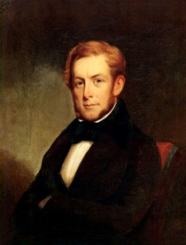
Courtesy of the Fenimore Art Museum, Cooperstown, New York. William Whipper, Attributed to William Matthew Prior, ca. 1835.
As a young man, William moved to Philadelphia and at first made his living as a steam scourer (at the time, a new process for cleaning clothing). Later, he opened a grocery store that supported temperance and sold mercantile goods that were created free of slave labor. The young professional and hard-working entrepreneur soon joined Philadelphia’s intellectual elites. He had connections to organizations and activities associated with the Bishop Richard Allen, founder of the African Methodist Episcopal Church. He became a valued member of new intellectual societies, including the “Reading Room Society for the Men of Colour who are Citizens of the City and Liberties of Philadelphia.” That society chose Whipper to draft their constitution. He would later become editor of The National Reformer, a magazine from the American Moral Reform Society dedicated to purifying individuals and society at large.
In the aftermath of a rebellion of enslaved Virginians in 1831, prosperous people of color faced turbulent opposition all over the country. One of the greatest losses was the ratification of a new Pennsylvania state constitution that denied Black men, who previously voted as lawful citizens, of that right. White-led riots occurred in Philadelphia and Columbia and anonymous death threats were received by Black businesspeople like Columbia’s Stephen Smith. Indignities were common. For example, Smith was the largest stakeholder in the Columbia-Wrightsville Bridge Company, but he was not allowed to serve as its president.
William’s role as a national leader was demonstrated in 1833 when he was chosen to write and deliver the Philadelphia eulogy for William Wilberforce. Wilberforce had been the face of the victorious abolition movement in Great Britain. In his address, Whipper not only exalted Wilberforce, he also castigated the American Colonization Society, an organization formed to encourage free African Americans to move to Africa, as “the arch enemy of liberty.” It was a dangerous time to be so bold.
Making Columbia Home
1850 Map of West Hempfield Township including property owners. Notice Whipper & Smith own multiple businesses and dwellings near the end of the bridge.
William Whipper left Philadelphia and settled in Columbia in 1835. In 1836, he married Stephen Smith’s only daughter, Harriet. The following year they welcomed a daughter, who they also named Harriet. Whipper spent three decades in Columbia. He managed lumberyards, investments in the Columbia and Reading Railroad, and other properties by day and operated a crucial Underground Railroad station at night. In Columbia, William had a unique opportunity to offer direct support to freedom seekers. Many freedom seekers found employment in his lumberyards, as it was excellent work for men of color that paid a living wage. The lumberyards also functioned as a clandestine station in a Black Abolitionist network involving transporting freedom seekers in railway cars. Whipper worked with the successful Black businessman William Goodridge, who operated the Reliance Line in York. Goodridge and Whipper built secret compartments in their railcars to aid freedom seekers on their journey. Seekers often moved from York to Columbia and then on to Philadelphia.
He wrote of these activities:
“…the Susquehanna River was the recognized Northern boundary of the slave-holding empire. The borough of Columbia, situated on its eastern bank, in the county of Lancaster, was the great depot where the fugitives from Virginia and Maryland first landed. The long bridge connecting Wrightsville with Columbia was the only safe outlet by which they could successfully escape their pursuers…my house was at the end of the bridge, and as I kept the station, I was frequently called up in the night to take charge of passengers. On their arrival they were generally hungry and penniless. I have received hundreds in this condition; fed and sheltered from one to seventeen at a time in a single night…I passed hundreds to the land of freedom.”
Whipper’s Canadian Haven
Following the passage of the Fugitive Slave Act of 1850, conditions in Lancaster and Philadelphia became even worse for African Americans. In Columbia, Southerners came to kidnap free black people who had been formerly enslaved. This prompted Whipper to consider emigrating to Canada. In 1853 he traveled to Ontario, purchased property, and started a business venture in the town of Dresden. A few of his immediate family, including his sister, moved there permanently. William visited Canada annually and recommended Canada as the only haven for freedom seekers.
He later wrote in a letter to William Still, “I always persuaded them to go to Canada, as I had no faith in their being able to elude the grasp of the slave-hunters. Indeed, the merchants had the confidence of their security and desired them to remain; several of my friends told me that I was injuring the trade of the place by persuading the laborers to leave. Indeed, many of the fugitives themselves looked upon me with jealousy and expressed their indignation at my efforts to have them removed from peace and plenty to a land that was cold and barren, to starve to death.” Dresden was a hub for freedom seekers as there was agricultural land and lumber trade under the passionate leadership of Josiah Henson. His memoirs inspired author Harriet Beecher Stowe to write Uncle Tom’s Cabin.
Later Life
Courtesy of ExplorePAHistory.com. William Whipper, circa 1870.
Whipper returned to Philadelphia after the Civil War, but still held on to some of his Columbia properties. He continued to advocate for the rights of African Americans through newspaper articles and speeches. These efforts culminated in 1866, when William joined Frederick Douglas in an historic meeting with President Andrew Johnson to advocate for Black suffrage. Although Johnson rejected their proposal, Congress passed the 15th Amendment, that gave Black men the right to vote, four years later. Sadly, in actual practice, state and local laws and threats of violence often kept Black men from doing so.
William Whipper died in Philadelphia on March 9, 1876, as a respected entrepreneur, abolitionist, and thinker. He was born in Lancaster County, and during his time in Columbia he helped hundreds of freedom seekers. But he was more than just a local hero. His actions before and after the Civil War contributed significantly to the fight for freedom and equality for Black people throughout the nation.
Learn more
Read William Whipper own words from this letter describing his freedom fighting activities to William Still. Click Transcription or Images to see the letter. “William Whipper to William Still, December 4, 1871,” House Divided: The Civil War Research Engine at Dickinson College.
Baptist, Edward E. The Half Has Never Been Told: Slavery and the Making of American Capitalism. New York: Basic Books, 2016.
Ellis, Franklin and Samuel Evans. History of Lancaster County, Pennsylvania, with Biographical Sketches Of Many Of Its Pioneers and Prominent Men. (Philadelphia, Everts & Peck, 1883): 796.
Gallas, Kristin L. and James DeWolf Perry. Interpreting Slavery at Museums and Historic Sites. Lanham, Maryland: Rowman & Littlefield Publishing Group, 2015.
River Roots is Susquehanna NHA’s blog series featuring history from York and Lancaster Counties that showcases the Susquehanna River’s historic, cultural, and natural resource contributions to our nation’s heritage.
For those who live along the Susquehanna River’s banks, ice is a common winter sight. It has jammed on the Susquehanna since the rocky ridges of our region rose up around the river. Residents harvested ice as a winter crop for use in iceboxes before modern refrigeration. However, when the conditions are right, ice can be terribly destructive on our waterways. Ice jams are responsible for some of the most devastating flooding events on the Lower Susquehanna.
What is an ice Jam?
An ice jam is an obstruction of broken-up ice that clumps together to block the flow of a waterway. There are two types of ice jams: freeze-up, and break-up. Freeze-up ice jams happen in the early to mid winter, when changing water slows or stops floating ice as it reaches an obstruction. Beak-up jams occur during late winter and early spring thaws. They are usually associated with a rapid increase in runoff, because warm temperatures and heavy rain cause snow to rapidly melt. Heavy rainfall or fluctuating temperatures break up the ice cover. Melting snow and ice can swell the river, which breaks the surface layer of ice. Increasing water levels can lift and break ice cover, carrying frozen chunks downstream. As floating ice builds up, it forms thick layers that sometimes reach great heights. Ice jams commonly develop near river bends, mouths of tributaries, and points where the river slope decreases. They also form downstream of dams and upstream of bridges. The accumulation of ice obstructs the flow of water, resulting in increased and unpredictable local flooding.
Ice jams can stay in place for a few minutes or many days. They can stretch a few hundred feet or many miles long. Ice jam floods are less predictable and potentially more destructive than typical open-water flooding. They can produce much deeper and faster flooding that lasts longer.
Frozen Susquehanna River
Historic Ice Jams on the Lower Susquehanna
Ice on the Susquehanna River is both interesting and concerning. Although not every ice jam is dangerous, this natural phenomenon can be catastrophic in the Susquehanna River region. The first Euro-American records of an ice jam flood on the Susquehanna date back to 1784. Ice ruined many bridges, canals, railroads, and communities on the Susquehanna (and its tributaries) throughout the 19th and 20th centuries. We’ll touch on just a few of those notable instances in the region.
1832 First Columbia and Wrightsville Bridge Destroyed
During an extremely cold winter in 1832, thick ice hardened on the Susquehanna and stacked to great heights where the river was shallow. Spring thaw came quickly and created the right conditions for ice jam flooding. When the ice began to break up and flow down the river, the water rose 30 feet! It swept homes, barns, and even cattle along the river. Ice jammed up south of Columbia and created a natural dam. Water and ice rose and lifted the first bridge that spanned the Susquehanna off its piers. The flood destroyed the bridge, the longest covered bridge in the world at the time.
1904 Great Ice Flood
The stage was set for natural disaster in 1904, when an especially frigid winter froze the Susquehanna solid. Merchants crossed horse-drawn freight wagons between Lancaster and York counties on the 2ft thick ice. However, when the ice began to break up, it caused the greatest flood ever on the Susquehanna.
Village of Collins 1904York Haven Dam 1904
Just as workers were putting the finishing touches on the York Haven Dam (one of the first hydroelectric projects on the Lower Susquehanna River), the ice jammed. Ice and flooding collapsed the superstructure of the building and caused major damage. The floodwaters rushed downriver, carrying blocks of ice with it, that battered the paper mill at York Haven. The ice almost completely destroyed the village of Collins in Conoy Township; after the ice flood, all that remained of the town was a single railroad control tower.
Lancaster New Era March 7, 1904
The flowing flood waters and ice met with an ice gorge in Bainbridge and began to flow downriver. The water dislodged the Bainbridge train station and carried it a mile south on the railroad tracks. The river washed away parts of the newly constructed bridge of the Atglen and Susquehanna (A&S) line, taking the Shocks Mill Railroad Bridge with it. Mud and ice coated river towns like Marietta, Columbia, Wrightsville, and Washington Boro as the river pushed the destruction downriver.
Thousands visited Columbia and Wrightsville to view the immense buildup of water and ice. The tower almost reached the steel railroad bridge and everyone feared that the ice would destroy the great structure, especially after part of the new railroad bridge was carried down against it.
The floodwater and ice combined with and dislodged an ice gorge at Turkey Hill, south of Columbia. This formed an enormous ice gorge below Safe Harbor. At Turkey Hill, 30 feet of water covered the railroad tracks, which are 20 feet above the low water mark. The river had risen to about 50 feet deep. Once the river found its way through the blockage, it destroyed a significant section of Safe Harbor village. The violent rush of floodwater only lasted 15 minutes. Together, the ice and floodwaters crushed, mangled, and lifted buildings from their foundations as it submerged part of the town. The flood tore away the stone Pennsylvania Railroad (PRR) bridge that crossed the Conestoga River. In Pequea, the water rose 12ft in 10 minutes and pushed another bridge up Pequea Creek.
Village of Safe Harbor 1904Village of Safe Harbor 1904
The PRR mainline to Columbia and the Columbia & Port Deposit Railroad (C&PD) were both badly damaged. PRR’s Low-Grade line was in the process of being laid out but had to halt construction. The railroad beds were greatly damaged requiring lengthy repairs. The flood tore away sections and wedged them under huge cakes of ice. For about a week, the tracks were useless, blocked by floods that carried millions of tons of ice downriver. The railroad lines froze; ice was up to 30ft deep in some spots. Wreckage of buildings, masses of rock and earth, trees, and all sorts of debris covered the railroads.
PRR bridge over Conestoga River 1904PRR Safe Harbor area 1904
The PRR pulled men off the Low-Grade construction crews to work on opening the line between Columbia and Harrisburg. Equipped with six steam shovels, they attacked the ice that covered the railroads. It took quite a while to resume service on the mainline via Columbia. The standstill congested freight at Harrisburg and forced passenger trains to run lengthy alternative routes.
1920 Interesting Solution
In 1920, the Susquehanna River froze sold for 83-day streak. In early March, a quick thaw caused severe ice jams. They were so severe that an unorthodox solution to prevent the devastating flooding: they decided to drop bombs on the Susquehanna River. Colonel H. W. Scull, who is credited for the idea, received permission to execute the experiment.
The Colonel oversaw several days of aerial bombing, using 250lb TNT bombs to break up the 16-foot-thick-jams. The bombs seemed successful, until the ice jammed up again. The next day, they dropped four 500lb TNT bombs into the ice gorge between Port Deposit and Havre de Grace, successfully allowing the jam to start flowing. Following that success, arrangements were made to bomb the ice-choked sections of Columbia, Safe Harbor, Washington Boro, and Holtwood. It was decided that bombing the river above the Conowingo Dam wasn’t necessary, as weather conditions allowed for a safe thaw.
March 1920 Headline of The Lancaster Intelligencer
Today, warmer weather conditions mean less aggressive ice buildup on the Lower Susquehanna River. It’s difficult to imagine the destructive force and sheer heights of the ice responsible for such a destruction.
York Daily issue of May 17, 1875
Learn More
Visiting the Susquehanna River during winter provides a unique and memorable experience! Ice building up along the riverbank creates a stunning winter landscape to enjoy. As ice crunches against ice, ominous creaking and groaning sounds fill the air. Thick slabs of ice let out thunderous booming sounds as they expand over the riverbank. It’s no wonder why the people of York and Lancaster counties flooded to the river to see this great spectacle for centuries.
River Roots is Susquehanna NHA’s blog series featuring history from York and Lancaster Counties that showcases the Susquehanna River’s historic, cultural, and natural resource contributions to our nation’s heritage.
On December 14, 1763, 56 vigilantes brutally murdered and mutilated six Conestoga Indian women and children. The mob, known as the Paxton Boys, rode into the small village east of Turkey Hill intending to murder all twenty residents.
This map shows the general location of Conestoga Indian Town, or Conestoga Mannor. Courtesy ExplorePAHistory.com
Satellite imagery of the Indian Town site today. Courtesy of GoogleMaps.
About fourteen people, mostly men, had happened to be away from the village during the massacre. They were were taken to the Lancaster workhouse for their safety. But, on December 27th, while the people of Lancaster were in church holding a Christmas service, the Paxton Boys broke in and murdered them.
It can be easy to become numb to such atrocities when studying American history, to write it off as another example of frontier violence. However, the Paxton Boys Massacre was the result of a complicated web of social, religious, financial, and cultural tension. By studying it, we can better understand just how turbulent life was in central Pennsylvania on the eve of the American Revolution.
From One War to Another
When the French and Indian War* ended in early 1763, many British colonists would have celebrated. The French had lost all their North American claims. The British empire had also defeated the Native Americans, who had largely allied with the French after decades of trading with them. As far as the colonists cared, the door to the Ohio Valley and the rest of the lands west of the Appalachian Mountains was now wide open. After all, many men who had fought for wealthy land speculators under the impression that they would receive western lands after the war.
European claims in North America before and after the Seven Year’s War. Courtesy of schreinerus8.weebly.com
British colonists began streaming west, eager to enjoy what they thought of as the spoils of war. However, the Native people (and, to a lesser extent, French settlers) wanted to fight back against British colonization. A mere three months after the Treaty of Paris, Ottawa, Huron, Pottawatomi, and Ojibwa warriors organized by an Ottawa warrior named Pontiac attacked Fort Detroit. Over the next few months, the Native tribes and nations took several forts in the Great Lakes and Ohio Valley regions and besieged others.
This confederation of tribes that fought in this conflict (which has come to be known as Pontiac’s War or Pontiac’s Rebellion) was one of the first and most wide-reaching inter-tribal alliances in the history of North America. Native tribes did not act as monoliths; for example, some Ottawa leaders chose to join Pontiac, but not all. But, huge percentages of Native America did join together against British colonization. Ottawas, Hurons, Ojibwes, and Potawatomis from the Great Lakes, Miamis, Weas, Kickapoos, Mascoutens, and Piankashaws from the Illinois Country, and Lenape, Shawnees, Wyandots, and Mingos from Pennsylvania and Ohio all attacked the British backcountry. Even some Seneca, who were part of the Haudenosaunee (Iroquois) Confederacy alliance with Great Britain, supported Pontiac’s War.
Courtesy of APUSHCanvas
After the French and Indian War, many Native people were done with European alliances. After all, their long-standing relationships with France had meant nothing when France gave England huge swaths of Native land in the Treaty of Paris. Even those who had allied with Great Britain, like the Haudenosaunee, were losing more and more land. In addition to the political and economic pressure to ally with each other against Europe, many Native groups were experiencing religious revivals. Leaders and prophets were urging their followers to embrace traditional spirituality and to reject European goods (especially alcohol), beliefs, and practices.
Instead of peace, the end of the French and Indian War brought increased frontier violence. Native people attacked settlers to deter westward colonization and to support their tribes through taking and selling captives. Settlers, in turn, attacked Native people indiscriminately. Many found it easier and easier to dehumanize Native people and to see them as little more than a barrier to westward expansion.
1763 Proclamation Line
However, the British government did not need western settlement in 1763. Unlike France, who mostly wanted natural resources from the interior, Great Britain wanted her colonies to be a ready market for British goods. Self-sufficient homesteaders, far from ports and harbors weren’t a priority for parliament. Britain was also keen to avoid another expensive war in North America. The National Debt had ballooned from £75 million in 1756 to £133 million at the end of the war.
Hoping to kill two birds with one signature, King George III issued the Royal Proclamation of 1763. It stated, explicitly, that Native peoples were the original owners of all land in North America, and that only the Crown could buy it from them. The document also banned British settlement west of the Appalachians.
Map showing the 1763 line. Courtesy of Britannica.com
King’s proclamation angered colonists. Pennsylvanians, in particular, chafed at the thought of limiting westward settlement. The Ohio Country was one of the biggest prizes of the French and Indian War. Plus, the Proclamation Line effectively cut Pennsylvania in half.
As Pontiac’s War waged in the backcountry, the mostly Scotch-Irish, Presbyterian settlers of western PA grew angry when the pacifist Quakers refused to create a standing army to fight against Native attacks. On the other hand, the Scot-Irish refugees who were streaming east to avoid the violence on the frontier frightened the Philadelphians. Instead of joining the settlers in their war, many of the Quakers in power wanted to focus on ending the conflict by placating Native people. The settlers felt that the British and the Pennsylvanian governments had both abandoned them.
Conestoga Indian Town
In the 1680s, about 200 Susquehannock people founded Conestoga Indian Town. These people, the Conestogas, initially lived under the protection of the Penn family. As Pennsylvania became increasingly settled and that protection waned, the Conestogas largely assimilated into the local, dominant German and English cultures. By the 1760s, even though the Conestogas were technically protected by the Quaker government, Conestoga Indian Town looked very much like other Christian, Euro-American towns in the area.
However, as tensions increased on the frontier, the Conestogas’ settler neighbors trusted them less and less. Some of those neighbors began to refuse to do business with the Conestogas or to provide them with supplies. They feared that the Conestogas were funneling food or weapons to those fighting with Pontiac in the west. Conestoga leaders petitioned the Quakers for supplies in November of 1763:
To the Honorable John Penn, esquire, lieutenant Governor and Commander-in-chief of the Province of Pennsylvania,
Brother: We (the Conestoga Indians) take the present opportunity, by Captain Montour, to welcome you into this Country by this string of Wampum and as we are settled at this place by an agreement of peace and amity established between your grandfathers and ours, we now promise ourselves your favor and protection, and as we have always lived in peace and quietness with our Brethren and neighbors round us during the last and present Indian Wars, we hope now, as we are deprived from supporting our families by hunting, as we formerly did, you will consider our distressed situation and grant our women and children some clothing to cover them this winter. The government has always been kind enough to allow us some provisions, and did formerly appoint people to take care of us, but as there is no person to take that upon him, and some of our neighbors have encroached upon the tract of land reserved here for our use, we would now beg our brother, the Governor to appoint our friend Captain Thomas McKee, who lives near us and understands our language, to take care and see Justice done us.
SOHAYS, his mark
CUYANGUERRYCOEA, his mark
SAGUYASOTHA (JOHN), his mark (Colonial Records 9:88)
Just a month later, the Paxton Boys destroyed the entire town and massacred all of its residents. It can be tempting to see the attack as just another bloody episode of back-and-forth violence during a particularly bloody year. However, the killings were also unavoidably political. By doing their best to destroy even these “friendly Indians,” the Paxton Boys were sending a message to the Quakers. If Pennsylvania wasn’t going to fight the Indians for the settlers, then the settlers would take matters into their own hands and fight all Native people, no matter their relationship with Quakers.
Aftermath
The Quakers’ disproportionate control over the legislature and their failure to defend the frontier angered backcountry Pennsylvanians. After Paxton Boys’ Massacre of the Conestoga, about 600 armed frontiersmen marched to Philadelphia. A delegation of prominent Philadelphians, including Ben Franklin, met the protesters. They stopped the mob from entering the city by promising them that the legislature would hear their complaints. The assembly offered no redress for the protesters’ main grievances and publicized the incident.
The government issued proclamations ordering the Paxton Boys’ arrest. However, many frontiersmen were sympathetic to their actions. None of the men were arrested and they were so well protected that most of their identities are unknown to this day.
The “Conestoga Indians” descended from the Susquehannock and refugees from other tribes. Historians often use the massacre as a convenient way to end the Susquehannock story. However, other Susquehannock people had spread far and assimilated into the Seneca, Cayuga, and Oneida nations in New York’s Finger Lakes Region. Others married European traders and settlers, entering into the new American culture. John Skenandoa, a noted Oneida pine tree chief more widely known as Shenandoah, was born Susquehannock. A seventh-generation descendant, Joanne Shenandoah, continues the Susquehannock legacy as a Grammy Award-winning singer and composer.
* The French and Indian War (1754-1763) is the name for the North American phase of a war between France (and French-Allied Native Americans) and Great Britain (and British colonists and some British-Allied Native Americans). It eventually spiraled into a larger conflict involving most of Europe and parts of Asia. This larger war is called the Seven Years War (1756-1763), but the two names are sometimes used interchangeably. Just to make it even more confusing, some historians argue that the entire conflict was just part of the War of Austrian Succession, making it a 23-year-long war, not seven!
Columbia & Susquehanna Through the Lens of John Reitzel
Now on display at Columbia Crossing River Trails Center, Susquehanna NHA presents: “Columbia & Susquehanna: Through the Lens of John Reitzel.” Reitzel is a Columbia native and amateur photographer. Visitors to this brand-new exhibit will see his photography of scenes from around Columbia and along the lower Susquehanna River in handmade frames.
John Reitzel is an Air Force veteran and has 35 years of experience as a color analyst in the catalog and magazine printing industry. He has captured the river and the town in a variety of forms, colors, and seasons. Enjoy some of his favorite works alongside a brief historical note related to the view. Reitzel’s talent extends beyond the camera to woodworking, which he has been doing for nearly 30 years. All the photo frames in this exhibit are handmade by John.
“My passion for photography started 2 years ago when my wife and I went on a trip to Yosemite. I bought a camera to document the trip and realized how enjoyable it can be to take pictures. I’ve always felt a close connection to nature, and being a lifelong resident of Columbia, photography helped me discover the amazing things we have right in our backyard.” – John Reitzel
Enjoy Reitzel’s perspective of his hometown, Veterans Memorial Bridge, and Susquehanna River wildlife. Recently Reitzel was recognized in the Susquehanna Greenway Photo Contest, in which he won first place in the River Towns category and second place in the Susquehanna Adventures category. “Columbia & Susquehanna: Through the Lens of John Reitzel” will be on display at the Columbia Crossing River Trails Center through November. Visitors are welcome during operating hours: 10 am – 4 pm Tuesday through Saturday and 12 pm – 4 pm on Sundays. The exhibit is free, but donations are appreciated. Order forms are available in the exhibit at Columbia Crossing for those who wish to purchase any of Reitzel’s artwork.
River Roots is Susquehanna NHA’s blog series featuring history from York and Lancaster Counties that showcases the Susquehanna River’s historic, cultural, and natural resource contributions to our nation’s heritage.
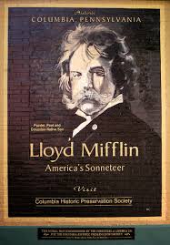
For National Poetry month, SNHA is featuring notable Columbia resident, Lloyd Mifflin, known for his success in the arts. His story is that of a talented painter and poet, whose love of the local native landscape was reflected in his work. Mifflin’s Susquehanna river scenes have served as representation of the Susquehanna River corridor’s exquisite natural beauty to the rest of the world. His poems convey a love affair with the river landscape. More celebrated for his poetry than his art, he was acclaimed as “America’s Greatest Sonneteer.” His legacy left his mark on the region and continues to captivate visitors 100 years after his death.
The Boy
Lloyd Mifflin was born on September 15, 1846 to John Houston Mifflin and Elizabeth Ann Bethel Heise in an elegant brick Federal-style townhouse on Walnut Street in Columbia, Pennsylvania. The Mifflin’s lived comfortably in their townhouse in Columbia, built by the Bethel family. They summered at their country estate, Norwood, just outside of Columbia on a hilltop overlooking the Susquehanna River. John Houston Mifflin built Norwood, named after the Mifflin’s family home in Warminster, England in 1850.
John Houston Mifflin raised his family in the virtues of old-fashioned chivalry, to be upholders of the American upper-middle class Victorian establishment. Lloyd Mifflin had a happy childhood, enjoyed a comfortable life, and never wanted for anything. In the Mifflin household, art and literature were important. Lloyd’s father was an amateur poet and had studied at portraiture at The Pennsylvania Academy of Fine Arts. He encouraged Lloyd to think for himself and develop his own tastes. Lloyd was sent to nearby country school in Norwood then attended the public schools in Columbia, although most of his education came from private tutors.
Lloyd was one of three children that survived to adulthood. Lloyd’s mother died when he was just eight years old. Elizabeth Ann Mifflin was buried in Mt. Bethel Cemetery in 1855. After his wife’s death, John Houston Mifflin inherited extensive land and financial holdings in Columbia. He gave up his art career to become a successful land developer and businessman.
Lloyd was drawn to the Susquehanna early in life. He grew up on the riverbanks drinking in the natural wonders of his local landscape. Mifflin developed a deep love of the Susquehanna river and spent most of his free time among its natural beauty reading his favorite poets or adventuring with friends. He developed a passion for the arts and a love of poetry. By age 14, Lloyd decided he wanted to be an artist.
The Artist
Acquiring talent and skill from his father, Lloyd continued to develop as an artist. He studied under Thomas Moran in Philadelphia from 1869 to 1870. Moran would go on to become famous for paintings of western mountains. Lloyd began to fall in love with landscapes. In 1871, Mifflin traveled the Susquehanna River from its source in Lake Otsego, Cooperstown, New York to Chesapeake Bay, making sketches of Pennsylvania towns and bridges during his journey.
View of the Susquehanna looking toward Turkey Hill
The following year, Mifflin left for Europe where he studied the great masters in the galleries throughout Europe. During his European tour, he learned from many successful artists of the time. He studied various landscapes and acquired a much more sophisticated use of color and light in his artwork. He returned home from Europe in 1873 a far more talented painter. Mifflin had a special talent for skillful depictions of landscapes with radiating light from the center of the picture that reflects off streams or objects. He was a master of tonality and luminosity.
He resumed his sketching expeditions, capturing the ageless beauty of Pennsylvania river valleys and towns. Lloyd Mifflin’s deep love of nature drew him to the Susquehanna time and time again. His “View of the Susquehanna Looking Toward Turkey Hill”, one of the first American scenes painted after his return from Europe, demonstrates his newly acquired skills. His best known and most widely admired works are those depicting the scenery of the Susquehanna River. He held a certain provincialism for his native region and refused to move to New York, even though Moran encouraged him to do so. During his lifetime, Mifflin did not need to sell his paintings to earn his livelihood. He lived a life of the landed gentleman that some described as a “highly sensitive, elitist dandy.”
Mifflin lived a style befitting a gentleman of means. He drove a coach-and-four, visited friends and relatives, “mixed with the very best sort of society”, and took up photography, creating thousands of glass-plate negatives and lantern slides. He developed into a good photographer over the years; the glass plate negatives served as photographic studies for his landscape paintings. Mifflin continued to take photographs until he suffered a heart attack in 1892. Convinced that the chemical fumes were harmful to his health, he gave up photography, although he continued painting sporadically.
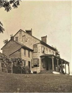
John Houston Mifflin died in 1888. As oldest son, Lloyd inherited the Norwood estate and a large portion of the family’s real estate holdings. This included not only land but extensive rental buildings, many in prime locations in Columbia. He took up residence in his fathers’ Norwood estate and greatly expanded it in 1901.
The Poet
In the 1890s, he was forced to give up the outdoor art of landscape painting due to continuing ill health, he focused on writing poetry that he had always enjoyed. Mifflin turned to poetry at the age of 51. He devoted his greatest efforts to the sonnet, considering it the most distinguished and exalted of all forms of English poetry. Mifflin aspired to write the perfect sonnet, a poem consisting of fourteen lines usually in iambic pentameter. He enjoyed the structure, lyrical beauty, the plan of metrical rhyme and diction. The rhyme schemes and diction include many metaphors and extensive use of vocabulary.
During his lifetime, Lloyd was widely recognized for his poetry. His work was very popular in England. His earliest commercial collection, “The Hills”, was published in 1896. He wrote more sonnets than William Shakespeare, John Milton, and William Wordworth in his lifetime. He published fourteen books, including 500 sonnets in his lifetime.
Mifflin never married; it is assumed that his work was his love. Through the years Lloyd was very generous in giving to causes, people and organizations. He donated paintings and books to be auctioned. He wrote many poems for organizations to commemorate special events. For years, Lloyd donated many of his books of poetry to colleges, libraries, and other institutions.
He suffered a stroke in 1915 while completing his last collection of sonnets, “As Twilight Falls”, which was published in 1916. He survived another 5 years before dying at his home on July 16, 1921. He was buried in the Old Brick Burial Yard within Mount Bethel Cemetery. He received honorary degrees in literature from University of Pennsylvania and Franklin Marshall College. Author, E. Hershey Sneath, wrote a book in 1928 that called Mifflin “the most prolific writer of sonnets in the history of English and American poetry.” The work was entitled America’s Greatest Sonneteer, which gave Lloyd the popular title, he is now known for.
In his will, he bequeathed land to the Columbia schools on both sides of Taylor school for a playground, with the conditions the land is not developed and that a student from the school place a flower on his grave every year on his birthday. The first tribute began that September and the tradition continues today, 2021 marks the 100th year.Typically, various sonnets of his are read aloud, hymns are sung, and sometimes guest speakers are featured.
The Mifflin family also supported local education by bequeathing two houses from their estate, the cottage known as Norwood and the grand house, Cloverton, to be sold to benefit local schools. Lloyd’s brother, Houston also donated land for a school playground. After Houston Mifflin’s death, a flower was also placed on his grave during the annual Lloyd Mifflin memorial ceremony.
Most of Lloyd Mifflin’s paintings that remained at the family summer home and were later acquired by the Pennsylvania Historical and Museum Commission. His drawings and manuscripts were acquired by Franklin and Marshall College in Lancaster, Pennsylvania. Many of his glass plate negatives remain in private hands, including one lot rescued from a refuse dump in Columbia.
This region was Lloyd Mifflin’s local landscape and his primary interest, as a boy, an artist, and a poet. The characteristics of his landscape paintings and the themes of many of his poems came from what he saw and experienced in his neighborhood. He left a legacy that showcases his natural talents, his passion and love for the Susquehanna, and generosity live on throughout the community he once called his home.
Learn more about Lloyd Mifflin
Lloyd Mifflin Mural on 2nd Street.
Want to learn more about Lloyd Mifflin’s well-known works? Read some of his river related poetry here. View the Visions of the Susquehanna exhibit is on display at the Zimmerman Center for Heritage or visit the State Museum of Pennsylvania, which holds the largest collection of Lloyd Mifflin paintings.
View the Lloyd Mifflin mural on the back on the Forrester’s building, near the entrance of the Columbia Historic Preservation Society, and visit the Columbia Historic Preservation Society to view their Lloyd Mifflin exhibit.
Take a scenic drive to view Norwood (511 Norwood Rd. Columbia, Pa) and Lloyd Mifflin’s Birthplace, the Cottage. (165 Walnut St. Columbia, Pa) Please remember these are private residences and do not trespass but view from afar.
Use the Mount Bethel Cemetery Brochure to locate Lloyd Mifflin’s gravesite and learn more about the annual memorial.
Sources
C. (2020, Spring). Lloyd Mifflin. Historic Times, 75, 1.
W., W. P. (1965). Lloyd Mifflin: Painter and poet of the Susquehanna. Harrisburg Pa.: Pennsylvania Historical and Museum Commission.
River Roots is Susquehanna NHA’s blog series featuring history from York and Lancaster Counties that showcases the Susquehanna River’s historic, cultural, and natural resource contributions to our nation’s heritage.
Stories of the Underground Railroad are inherently difficult to uncover and share. Unlike military or political history, few primary written records exist because assisting those escaping slavery was illegal and punishable with prison time and fines. Many enslaved people escaped without assistance and many supporters of the underground railroad were involved only periodically or occasionally. Stringing together the routes of the network, safe houses, and transportation methods has become a challenging but essential research interest of historians across the United States.
The Lower Susquehanna River Valley is particularly unique as the counties of York and Lancaster were hotbeds of abolitionist sentiment and Underground Railroad activity. Stories have been passed down from generation to generation about barns, basements, and cellars being used as hiding places. Historians sift through wills, deeds, newspaper ads, and genealogical information across multiple states and countries to tell the story of enslaved people, who became the agents of their own liberation. These accounts should not go unnoticed because the Underground Railroad story is a classic American story of “underdogs fighting the system with or without outside assistance.” (Leroy Hopkins in introduction to The Ground Swallowed Them Up.)
In the Susquehanna National Heritage Area, one site holds more definitive Underground Railroad history and significance than many others. It is the Hybla property just outside the town of Wrightsville in Hallam Township. Many people may know this property as the Mifflin Farm or Wright Mifflin Farm.
The Home at Hybla
19th Century View of Hybla Home from York County History Center
The first purchaser of the property was John Wright Sr., who established the ferry across the Susquehanna River in 1730 from present-day Columbia. He purchased hundreds of acres on the west side of the river in what became Hallam Township and passed it down to his children. There is contradicting accounts as to whether John Wright Sr. or his son James Wright erected the home on the property. James Wright died in 1788 and divided the property between his children. James’s daughter, Susanna, was given a 108-acre tract on which the Mifflin house is located. Susanna Wright Mifflin and her husband Jonathan Mifflin moved into the home on the property in 1800 after they married. They named the property Hybla.
After their deaths in 1829 and 1840, their son Samuel W. Mifflin lived at Hybla until 1846. During the nearly 50 years that the Mifflin family called Hybla home the Underground Railroad became the primary method to free enslaved people from southern states that refused to abolish the practice. Pennsylvania and many other Northeastern states had enacted gradual abolition of slavery before the turn of the century. The Wright and Mifflin families were staunch abolitionists. Their Quaker religion held that all people were equal under the eyes of God. Therefore, they should all be treated equally. It was not overnight that the Quakers chose to vehemently oppose slavery, but over the course of a century between 1675 – 1775 the religion developed a solid stance against the practice. Susanna, Jonathan, and their son Samuel were committed abolitionists publicly denouncing slavery at Quaker meetings and privately channeling freedom seekers across the Susquehanna River for half a century.
Underground Railroad at Hybla
Samuel W. Mifflin
In the early 1880s, Dr. Robert C. Smedley decided to record and publish accounts of Underground Railroad experiences in Southeastern Pennsylvania from interviews with its agents, conductors, and stationmasters. His narrative showcases primarily the free white supporters of freedom seekers and captures their memories of Underground Railroad activities. Smedley features Samuel W. Mifflin in his work History of the Underground Railroad in Chester and the neighboring counties of Pennsylvania. The account offers multiple stories of fugitives staying on the Hybla property, in the home, as well as being shuttled across the Susquehanna. Each short narrative showcases an important element or principle of the Underground Railroad’s operation.
“As far back in his boyhood as he can remember Samuel was accustomed to seeing fugitives passed along by different members of their family.” On one occasion, he recalled a freedom seeker was hidden in a cornfield and fed day after day by a cousin. The cousin would go out with his gun as if to hunt but his game bag was filled with provisions. (p. 48-49) It was very common for Quakers or abolitionists to offer a safe location on the property but not necessarily in the home. Cellars, barns, and in this instance, cornfields could be used to conceal freedom seekers, allowing them a few hours or days rest and recuperation before continuing their journey.
On a visit home to see his ailing father, Samuel found “the parlor occupied by thirteen fugitives. They comprised two families of men, women, and children whom his elder brother found wandering in the neighborhood. The windows were closed to prevent discovery, and a lamp kept burning all day. They were thus guarded during two days and nights of stormy weather and high water in the Susquehanna which prevented their crossing the river. On the third night they were transferred to the care of Robert Loney who ferried them over to the Columbia shore.” (p. 49)
This story, in particular, reveals an important element of the Underground Railroad that can be misunderstood – that African Americans were only shuttled to freedom by white abolitionists. In reality, African Americans were not passive figures but agents of their own liberation. These two families were found wandering and brought to the home. It is possible they had been assisted by a free Black or another white abolitionist and were told to head to Wrightsville on their path to freedom. It is also possible they headed to Wrightsville from rumors that the river there was the border with Canada. It was a common misconception because of how wide the river was at Wrightsville. Either way, it is important to remember that African Americans undertook the primary risk and struggle for freedom. There was a broad range of experiences and many made it without the support of the Underground Railroad network.
By far the most detailed story Smedley recounts about Hybla is that of Perry Wilkinson, an enslaved man and Baptist preacher. He was brought by a guide to the Mifflin’s at ten in the evening. Although he was offered a bed, Perry would not eat and paced the floor all night. He was thinking of his wife and family whom he had left behind. Perry had been enslaved in Anne Arundel, MD and was hired out on a boat that traveled between his master’s wharf and Baltimore. When his master died, Perry received word from a friend that his widow had decided to sell Perry. As soon as the boat landed in Baltimore, Perry journeyed north, traveling by night and hiding in the woods each day until he reached York and was brought to Samuel Mifflin. (p. 50-51) Although some freedom seekers had the opportunity to plan their journey, many others were forced, like Perry, to make a quick, deliberate, and difficult decision. No matter the choice that Perry made he would be separated from his family in a matter of days. Perry’s story is a representation of a truly dehumanizing nature of the chattel slavery in the United States.
Hybla’s Place in the Network to Freedom
Network Identified by Switala in Underground Railroad in Pennsylvania
Although there were thousands of unique experiences for fugitives on the path to freedom, historians have found some patterns in the routes. Dr. William Switala, a former professor at Duquesne University, studied these patterns and consistently found that the Underground Network between York and Lancaster County was connected across the river in three primary locations: York Haven – Middletown; Wrightsville – Columbia; and at the Peach Bottom Ferry. The York Haven – Middletown ford and ferry were used by freedom seekers that came through Lewisberry, a primarily Quaker town. Peach Bottom Ferry was primarily used by a conductor in Havre de Grace who would shuttle freedom seekers up through southern York County. The Wrightsville – Columbia connection was used more frequently than the other two for two primary reasons.
Columbia had a large free black population. When the town was laid out in 1787 the northeastern corner of town was set aside for manumitted slaves. Plus, both Columbia and Wrightsville had many Quaker residents who opposed slavery – particularly the Wright Family.
The network of Underground Railroad supporters in Wrightsville and Columbia crossed racial lines. There were not white abolitionists working separately from free black abolitionists, they worked together, which offered a variety of safe options even when those hunting fugitives were nearby.
Susanna, Jonathan, and Samuel primarily used the service of Robert Loney to move freedom seekers across the Susquehanna. Robert Loney was an African American boatman who was born enslaved in Virginia in 1815. Loney had settled in Columbia in 1819 when his family arrived after being manumitted. He would utilize a rowboat or raft to carry freedom seekers over to Columbia in the dark of night.
Samuel lived at Hybla until 1846, when his profession as an engineer took him out of state on projects. In the first half of the nineteenth century, the Underground Railroad evolved from a rough network of safe houses to a well-organized system. By 1850, when Congress passed the Fugitive Slave Act, the network had multiple layers, passwords/phrases, and travel tactics. For example, there were many Quaker women who were making large quantities of clean and mended clothing to be used by Underground Railroad station masters to help freedom seekers travel without being spotted as people formerly enslaved. By 1847, African American businessman William Whipper had begun an active role in the network. His lumberyard on the Columbia riverfront modified rail cars used in his business with secret compartments for fugitives from slavery.
The Hybla property will forever hold a pivotal place in Underground Railroad history, as an early, consistently used safe haven for African Americans seeking freedom. Whether they wandered into the neighborhood or were guided there, Hybla was central to the evolving network of black and white abolitionists and the freedom seekers who used that network to gain freedom over bondage.
Preserving the Mifflin House and Its Historic Landscape
Susquehanna National Heritage Area (SNHA), Preservation Pennsylvania, The Conservation Fund, and other partners have collaborated on a project to preserve the c.1800 Mifflin House and farmstead as an Underground Railroad and Civil War historic site since 2017. Kinsley Properties of York has been developing an industrial park around the site since the 1990’s with the Blessing family, long-time owners of the farm. As industrial development moved farther east toward the historic farmstead in 2017, demolition of the house, barn, and outbuildings was proposed, leading to much community debate and legal challenges.
As an alternative to demolition and development, the preservation partners proposed acquisition and adaptive use of the buildings and site as a regional heritage center and visitor attraction, with a historic park, nature preserve, and interpretive trails connected to a river park. The project concept plan, posted on SNHA’s website here, includes over 80 acres of Blessing/ Kinsley property and adjacent public and semi-public lands, including riverfront parcels owned by SNHA. In early 2019, the Blessings, Kinsley, and Hellam Township agreed to a two-year moratorium on demolition to allow the project partners time to develop a viable preservation, reuse, and funding plan for the site. These efforts have generated much local, state, and national support and a positive outcome for this important historic site is expected soon.
After acquisition funding was secured, The Conservation Fund purchased the property in April 2022 and the site was transferred to SNHA in December 2023 for implementation of the Susquehanna Discovery Center concept plan over 5-10 years. The plan includes the 87-acre Mifflin farm and 7 acres of other public and semi-public lands, including riverfront land owned by SNHA.
Schaefer, Elizabeth Meg. Wright’s Ferry Mansion. Columbia, PA: Von Hess Foundation, in association with Antique Collectors’ Club, Wappingers Falls, NY, 2005.
University of Chicago Press. “Founders Online: Virginia Delegates to Supreme Executive Council of Pennsylvani …” National Archives and Records Administration. National Archives and Records Administration. Accessed January 15, 2021. https://founders.archives.gov/documents/Madison/01-03-02-0092.
Wright, Samuel C. Hempfield: the Beginning of Columbia. Lancaster, PA: Lancaster County Historical Society, 1913.
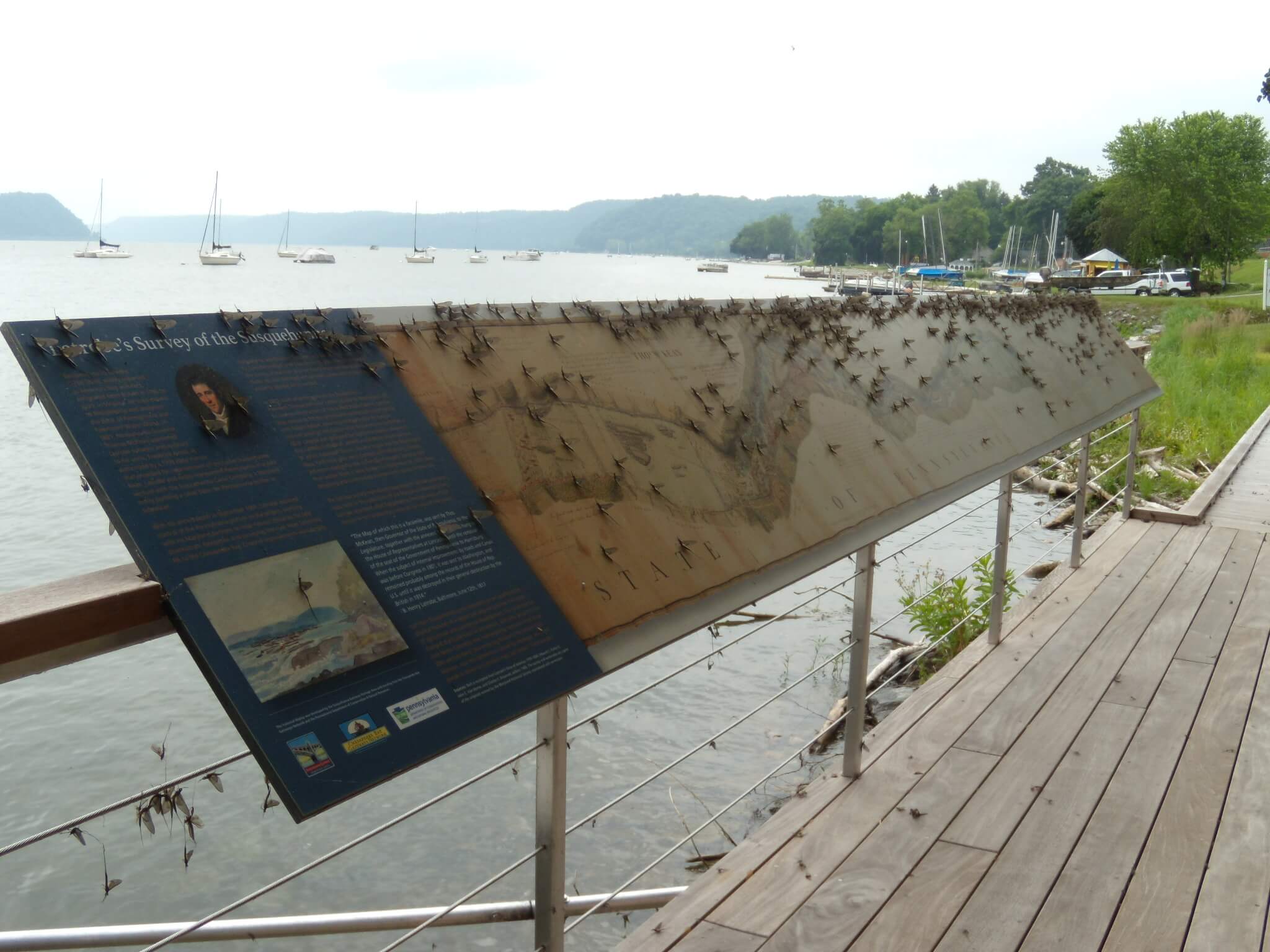

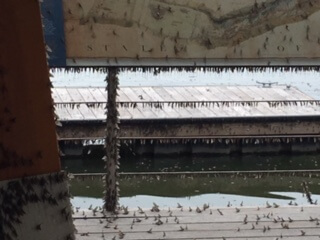
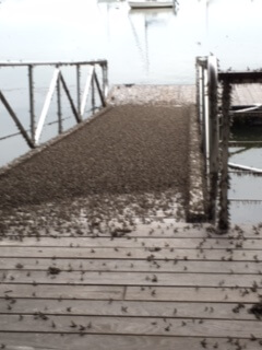
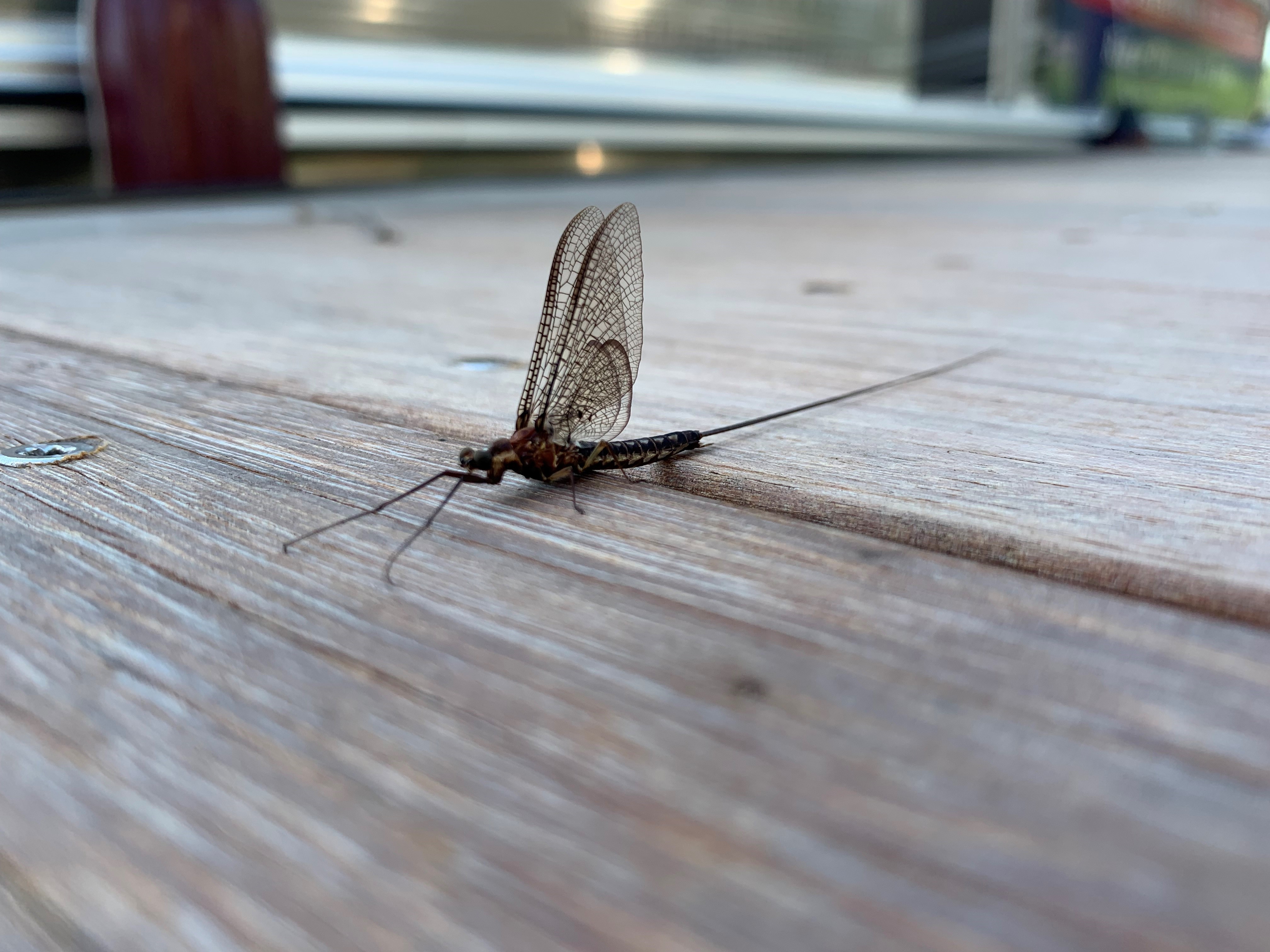 Mayflies are aquatic insects that belong to the order Ephemeroptera, which means “short-lived”. They are also known as shadflies, fishflies, or up-winged flies. They are ancient insects that have lived on this planet for over 350 million years. They even lived while dinosaurs were here. There are more than 600 species of mayfly in the United States and over 3,000 worldwide. In Pennsylvania, there are at least 175 different species. Mayflies can vary in size, but they typically grow anywhere from 0.25 to 1.1 inches. The largest species of mayfly in the world is the Tisza Mayfly, found in Eastern Europe. It measures 4.7 inches from head to tail. The Tisza Mayfly hatch has become a tourist attraction known as the “Blooming of the Tisza.”

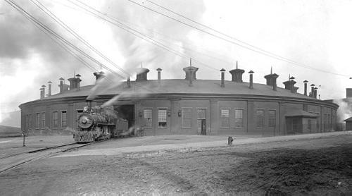
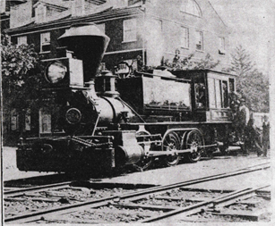
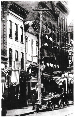
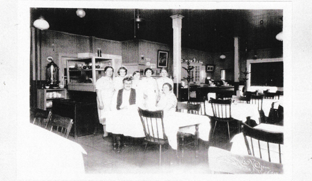


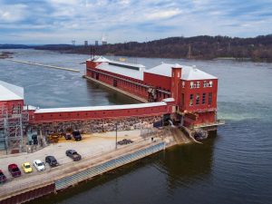 York Haven Hydro Station
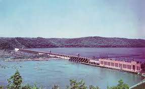 Safe Harbor Hydroelectric Station
 Holtwood Hydroelectric Plant (McCalls Ferry Dam)
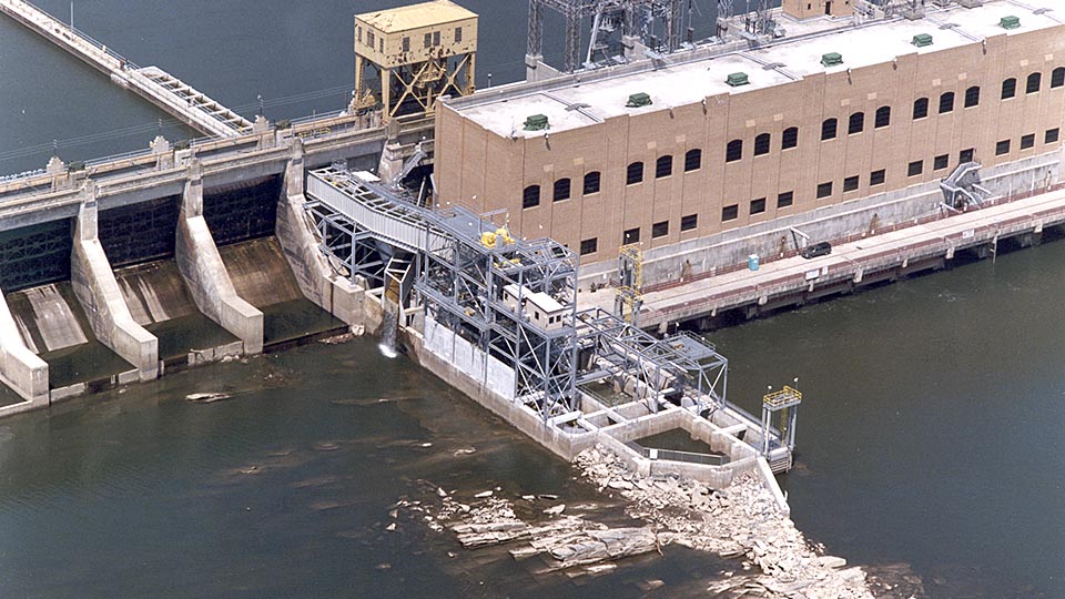

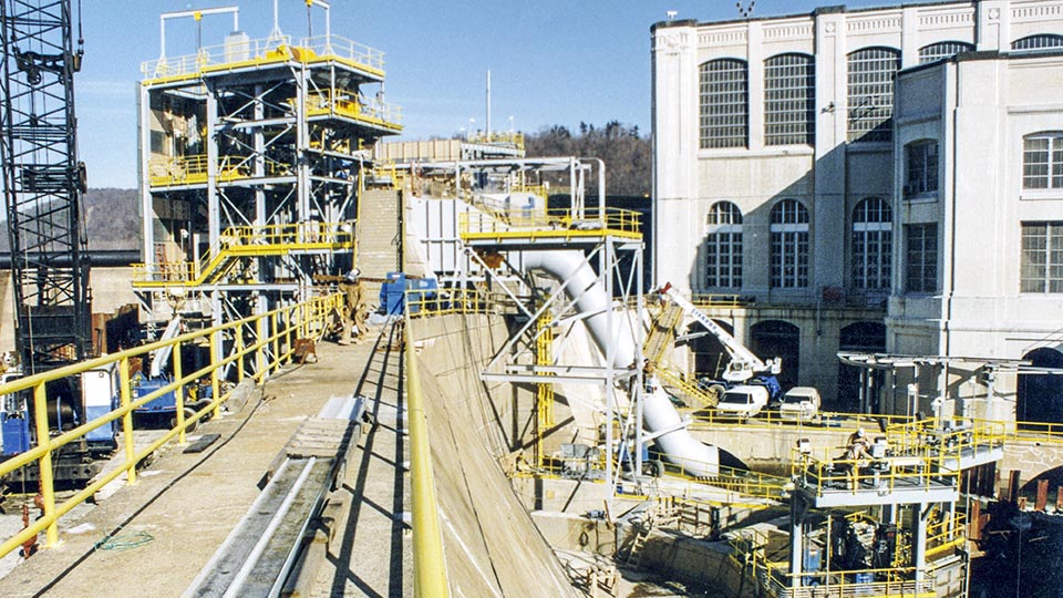

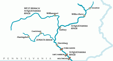

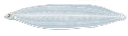


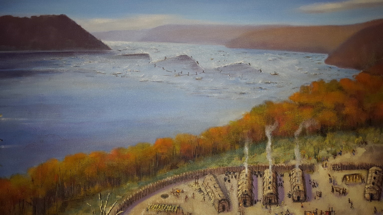

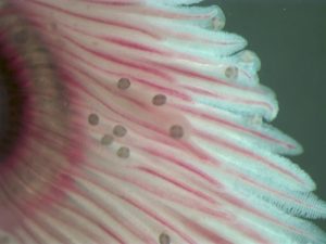


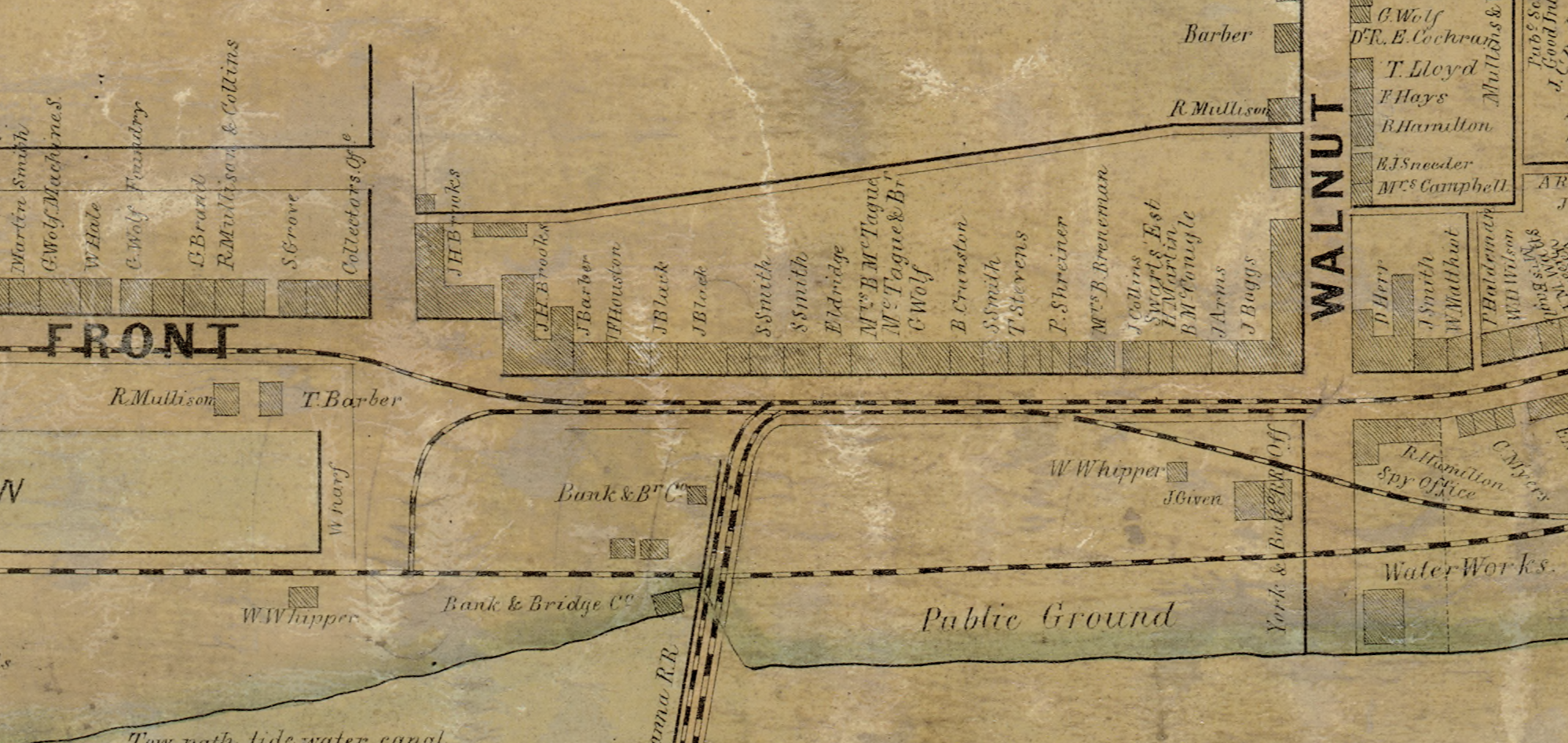


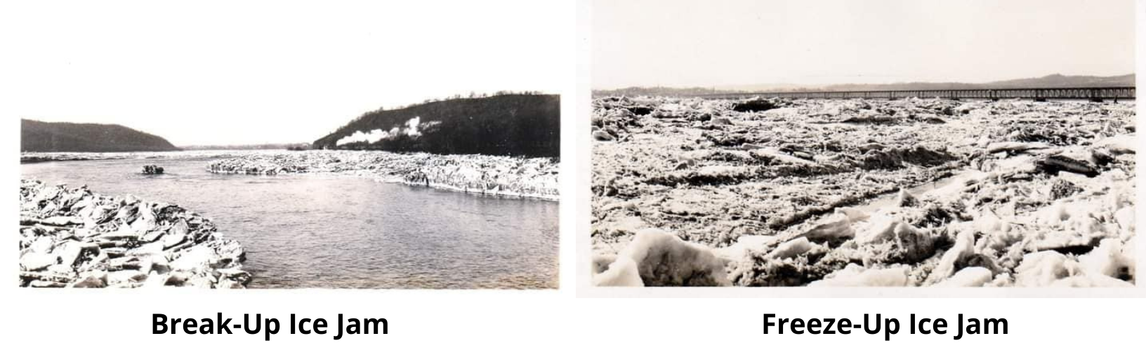
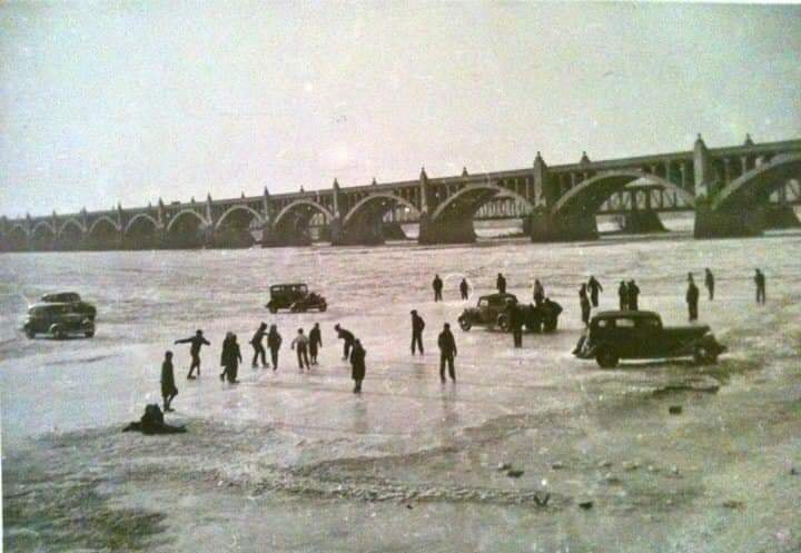


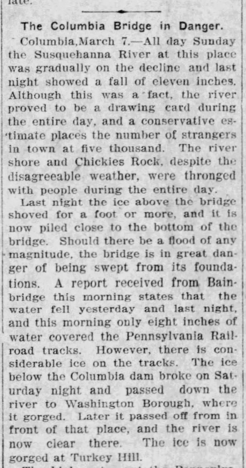
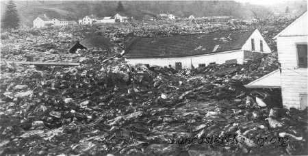
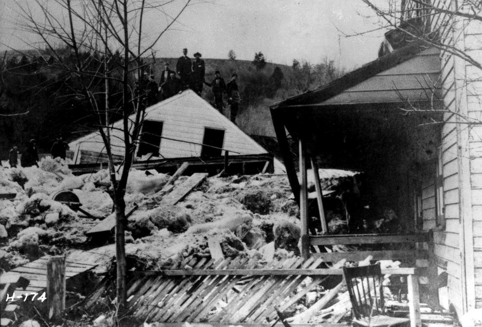

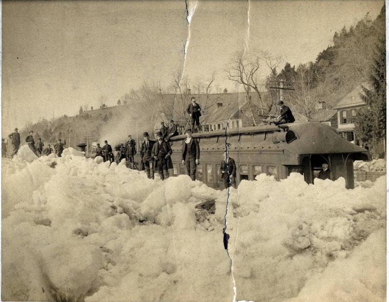
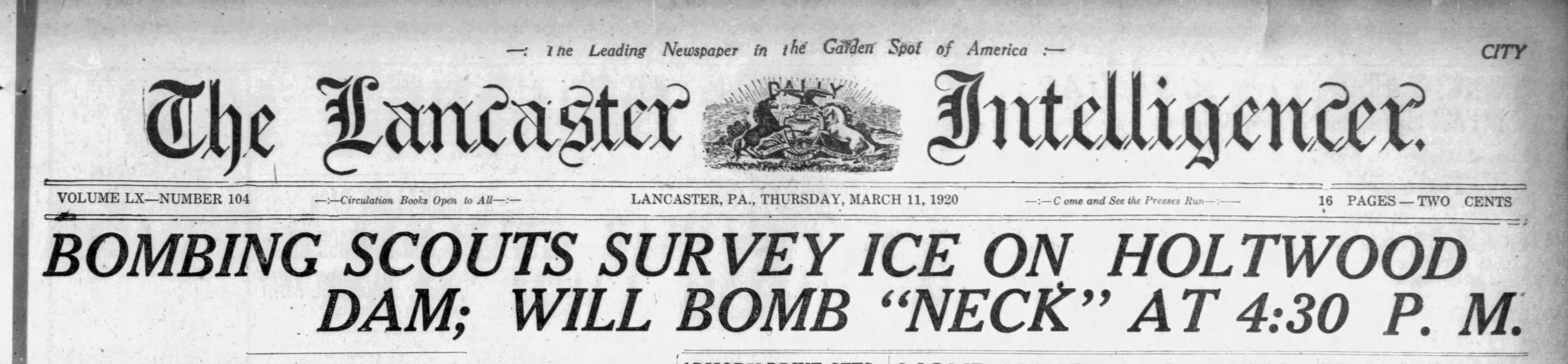
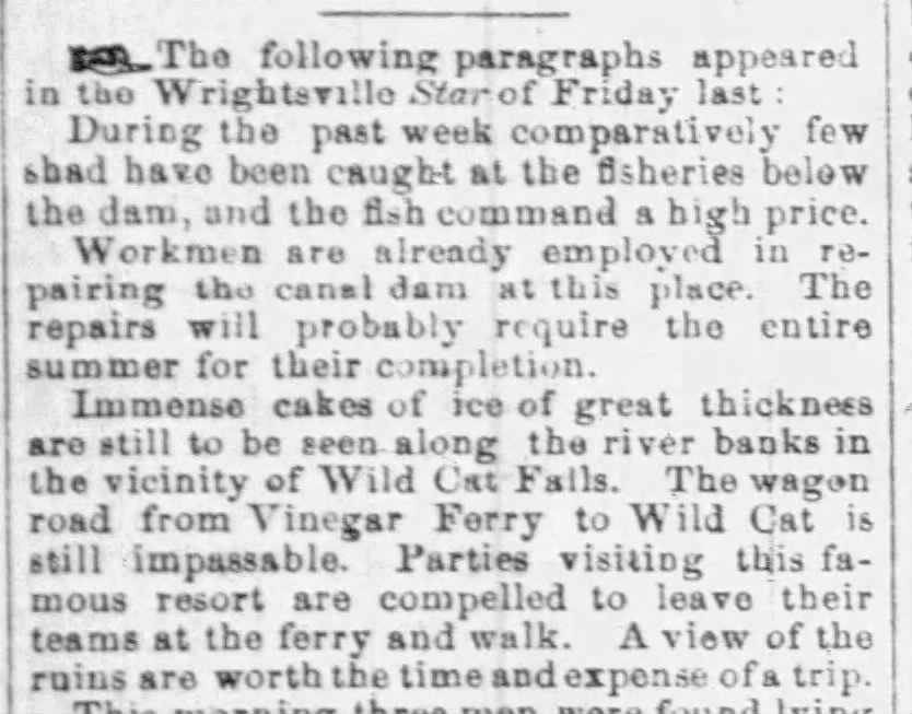
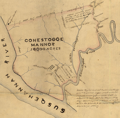
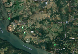
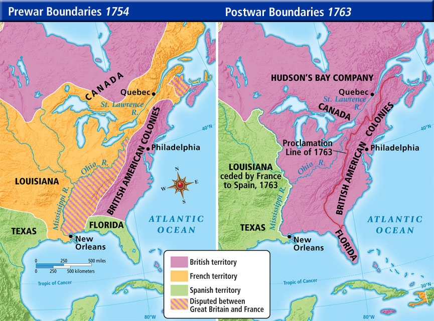

 brick Federal-style townhouse on Walnut Street in Columbia, Pennsylvania. The Mifflin’s lived comfortably in their townhouse in Columbia, built by the Bethel family. They summered at their country estate, Norwood, just outside of Columbia on a hilltop overlooking the Susquehanna River. John Houston Mifflin built Norwood, named after the Mifflin’s family home in Warminster, England in 1850.
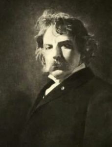
 In his will, he bequeathed land to the Columbia schools on both sides of Taylor school for a playground, with the conditions the land is not developed and that a student from the school place a flower on his grave every year on his birthday. The first tribute began that September and the tradition continues today, 2021 marks the 100th year. Typically, various sonnets of his are read aloud, hymns are sung, and sometimes guest speakers are featured.