River Roots: Pontiac’s War & The Paxton Boys
River Roots is Susquehanna NHA’s blog series featuring history from York and Lancaster Counties that showcases the Susquehanna River’s historic, cultural, and natural resource contributions to our nation’s heritage.
On December 14, 1763, 56 vigilantes brutally murdered and mutilated six Conestoga Indian women and children. The mob, known as the Paxton Boys, rode into the small village east of Turkey Hill intending to murder all twenty residents.
|
|
|
About fourteen people, mostly men, had happened to be away from the village during the massacre. They were were taken to the Lancaster workhouse for their safety. But, on December 27th, while the people of Lancaster were in church holding a Christmas service, the Paxton Boys broke in and murdered them.
It can be easy to become numb to such atrocities when studying American history, to write it off as another example of frontier violence. However, the Paxton Boys Massacre was the result of a complicated web of social, religious, financial, and cultural tension. By studying it, we can better understand just how turbulent life was in central Pennsylvania on the eve of the American Revolution.
From One War to Another
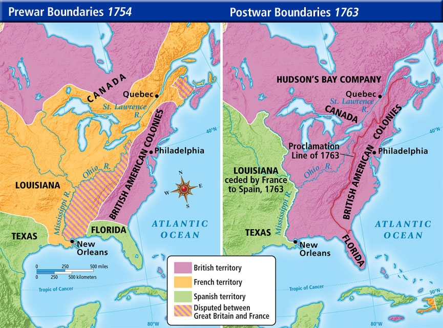
When the French and Indian War* ended in early 1763, many British colonists would have celebrated. The French had lost all their North American claims. The British empire had also defeated the Native Americans, who had largely allied with the French after decades of trading with them. As far as the colonists cared, the door to the Ohio Valley and the rest of the lands west of the Appalachian Mountains was now wide open. After all, many men who had fought for wealthy land speculators under the impression that they would receive western lands after the war.
British colonists began streaming west, eager to enjoy what they thought of as the spoils of war. However, the Native people (and, to a lesser extent, French settlers) wanted to fight back against British colonization. A mere three months after the Treaty of Paris, Ottawa, Huron, Pottawatomi, and Ojibwa warriors organized by an Ottawa warrior named Pontiac attacked Fort Detroit. Over the next few months, the Native tribes and nations took several forts in the Great Lakes and Ohio Valley regions and besieged others.
This confederation of tribes that fought in this conflict (which has come to be known as Pontiac’s War or Pontiac’s Rebellion) was one of the first and most wide-reaching inter-tribal alliances in the history of North America. Native tribes did not act as monoliths; for example, some Ottawa leaders chose to join Pontiac, but not all. But, huge percentages of Native America did join together against British colonization. Ottawas, Hurons, Ojibwes, and Potawatomis from the Great Lakes, Miamis, Weas, Kickapoos, Mascoutens, and Piankashaws from the Illinois Country, and Lenape, Shawnees, Wyandots, and Mingos from Pennsylvania and Ohio all attacked the British backcountry. Even some Seneca, who were part of the Haudenosaunee (Iroquois) Confederacy alliance with Great Britain, supported Pontiac’s War.

After the French and Indian War, many Native people were done with European alliances. After all, their long-standing relationships with France had meant nothing when France gave England huge swaths of Native land in the Treaty of Paris. Even those who had allied with Great Britain, like the Haudenosaunee, were losing more and more land. In addition to the political and economic pressure to ally with each other against Europe, many Native groups were experiencing religious revivals. Leaders and prophets were urging their followers to embrace traditional spirituality and to reject European goods (especially alcohol), beliefs, and practices.
Instead of peace, the end of the French and Indian War brought increased frontier violence. Native people attacked settlers to deter westward colonization and to support their tribes through taking and selling captives. Settlers, in turn, attacked Native people indiscriminately. Many found it easier and easier to dehumanize Native people and to see them as little more than a barrier to westward expansion.
1763 Proclamation Line
However, the British government did not need western settlement in 1763. Unlike France, who mostly wanted natural resources from the interior, Great Britain wanted her colonies to be a ready market for British goods. Self-sufficient homesteaders, far from ports and harbors weren’t a priority for parliament. Britain was also keen to avoid another expensive war in North America. The National Debt had ballooned from £75 million in 1756 to £133 million at the end of the war.
Hoping to kill two birds with one signature, King George III issued the Royal Proclamation of 1763. It stated, explicitly, that Native peoples were the original owners of all land in North America, and that only the Crown could buy it from them. The document also banned British settlement west of the Appalachians.
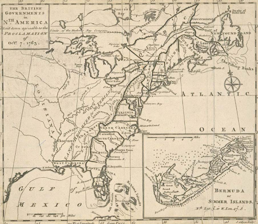
King’s proclamation angered colonists. Pennsylvanians, in particular, chafed at the thought of limiting westward settlement. The Ohio Country was one of the biggest prizes of the French and Indian War. Plus, the Proclamation Line effectively cut Pennsylvania in half.
As Pontiac’s War waged in the backcountry, the mostly Scotch-Irish, Presbyterian settlers of western PA grew angry when the pacifist Quakers refused to create a standing army to fight against Native attacks. On the other hand, the Scot-Irish refugees who were streaming east to avoid the violence on the frontier frightened the Philadelphians. Instead of joining the settlers in their war, many of the Quakers in power wanted to focus on ending the conflict by placating Native people. The settlers felt that the British and the Pennsylvanian governments had both abandoned them.
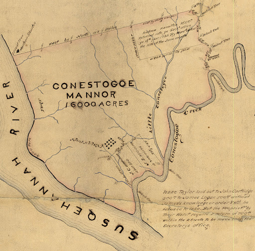
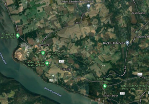
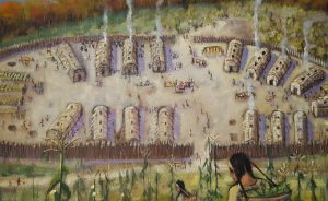
Conestoga Indian Town
In the 1680s, about 200 Susquehannock people founded Conestoga Indian Town. These people, the Conestogas, initially lived under the protection of the Penn family. As Pennsylvania became increasingly settled and that protection waned, the Conestogas largely assimilated into the local, dominant German and English cultures. By the 1760s, even though the Conestogas were technically protected by the Quaker government, Conestoga Indian Town looked very much like other Christian, Euro-American towns in the area.
However, as tensions increased on the frontier, the Conestogas’ settler neighbors trusted them less and less. Some of those neighbors began to refuse to do business with the Conestogas or to provide them with supplies. They feared that the Conestogas were funneling food or weapons to those fighting with Pontiac in the west. Conestoga leaders petitioned the Quakers for supplies in November of 1763:
To the Honorable John Penn, esquire, lieutenant Governor and Commander-in-chief of the Province of Pennsylvania,
Brother: We (the Conestoga Indians) take the present opportunity, by Captain Montour, to welcome you into this Country by this string of Wampum and as we are settled at this place by an agreement of peace and amity established between your grandfathers and ours, we now promise ourselves your favor and protection, and as we have always lived in peace and quietness with our Brethren and neighbors round us during the last and present Indian Wars, we hope now, as we are deprived from supporting our families by hunting, as we formerly did, you will consider our distressed situation and grant our women and children some clothing to cover them this winter. The government has always been kind enough to allow us some provisions, and did formerly appoint people to take care of us, but as there is no person to take that upon him, and some of our neighbors have encroached upon the tract of land reserved here for our use, we would now beg our brother, the Governor to appoint our friend Captain Thomas McKee, who lives near us and understands our language, to take care and see Justice done us.
SOHAYS, his mark
CUYANGUERRYCOEA, his mark
SAGUYASOTHA (JOHN), his mark (Colonial Records 9:88)
Just a month later, the Paxton Boys destroyed the entire town and massacred all of its residents. It can be tempting to see the attack as just another bloody episode of back-and-forth violence during a particularly bloody year. However, the killings were also unavoidably political. By doing their best to destroy even these “friendly Indians,” the Paxton Boys were sending a message to the Quakers. If Pennsylvania wasn’t going to fight the Indians for the settlers, then the settlers would take matters into their own hands and fight all Native people, no matter their relationship with Quakers.
Aftermath
The Quakers’ disproportionate control over the legislature and their failure to defend the frontier angered backcountry Pennsylvanians. After Paxton Boys’ Massacre of the Conestoga, about 600 armed frontiersmen marched to Philadelphia. A delegation of prominent Philadelphians, including Ben Franklin, met the protesters. They stopped the mob from entering the city by promising them that the legislature would hear their complaints. The assembly offered no redress for the protesters’ main grievances and publicized the incident.
The government issued proclamations ordering the Paxton Boys’ arrest. However, many frontiersmen were sympathetic to their actions. None of the men were arrested and they were so well protected that most of their identities are unknown to this day.
The “Conestoga Indians” descended from the Susquehannock and refugees from other tribes. Historians often use the massacre as a convenient way to end the Susquehannock story. However, other Susquehannock people had spread far and assimilated into the Seneca, Cayuga, and Oneida nations in New York’s Finger Lakes Region. Others married European traders and settlers, entering into the new American culture. John Skenandoa, a noted Oneida pine tree chief more widely known as Shenandoah, was born Susquehannock. A seventh-generation descendant, Joanne Shenandoah, continues the Susquehannock legacy as a Grammy Award-winning singer and composer.
* The French and Indian War (1754-1763) is the name for the North American phase of a war between France (and French-Allied Native Americans) and Great Britain (and British colonists and some British-Allied Native Americans). It eventually spiraled into a larger conflict involving most of Europe and parts of Asia. This larger war is called the Seven Years War (1756-1763), but the two names are sometimes used interchangeably. Just to make it even more confusing, some historians argue that the entire conflict was just part of the War of Austrian Succession, making it a 23-year-long war, not seven!
Learn More
Brubaker, Jack. Massacre of the Conestogas: On the Trail of the Paxton Boys in Lancaster County. (Available on the SNHA online store)
Green, John. “The Seven Years War: Crash Course World History #26.” CrashCourse (Youtube Channel)
RiverRoots: Susquehannock Culture
Sources
“Proclamation Line of 1763, Quebec Act of 1774 and Westward Expansion.” Office of the Historian.
“Confronting the National Debt: The Aftermath of the French and Indian War.” LumenLearning.
Goode, Michael. “Pontiac’s War and the Paxton Boys.” The Encyclopedia of Greater Philadelphia.
Green, John. “The Seven Years War: Crash Course World History #26.” CrashCourse (Youtube Channel)
Greenspan, Jesse. “How the Proclamation of 1763 Sparked the American Revolution.” History.
Kirk, Andrew. “Desperation, Zeal, and Murder: The Paxton Boys.” Pennsylvania Center for the Book.
Martin, Darvin L. “A History of Conestoga Indiantown.” Digital Paxton.
McCutchen, Jennifer Monroe. “Proclamation Line of 1763.” George Washington’s Mount Vernon.
“Royal Proclamation, 1763.” Indigenous Foundations.
Stewart, Austin. “Proclamation Line of 1763.” The Encyclopedia of Greater Philadelphia.


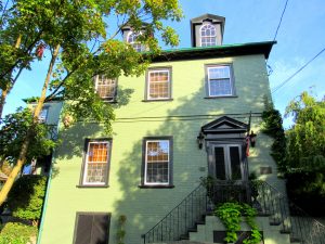 brick Federal-style townhouse on Walnut Street in Columbia, Pennsylvania. The Mifflin’s lived comfortably in their townhouse in Columbia, built by the Bethel family. They summered at their country estate, Norwood, just outside of Columbia on a hilltop overlooking the Susquehanna River. John Houston Mifflin built Norwood, named after the Mifflin’s family home in Warminster, England in 1850.
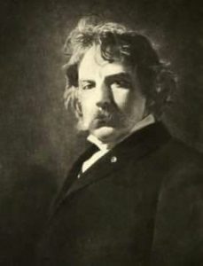
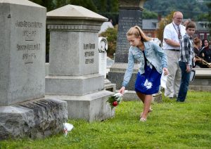 In his will, he bequeathed land to the Columbia schools on both sides of Taylor school for a playground, with the conditions the land is not developed and that a student from the school place a flower on his grave every year on his birthday. The first tribute began that September and the tradition continues today, 2021 marks the 100th year. Typically, various sonnets of his are read aloud, hymns are sung, and sometimes guest speakers are featured.