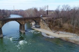
There is no doubt that the Northwest Lancaster County River Trail is the most popular hiking and biking trail in the Susquehanna NHA. In about a month, the trail will be complete from Columbia to Falmouth for a total of 14 miles. The trail offers trips through wooded areas, rolling farmland, and historic river towns. It also has many remnants from centuries of riverfront industry. Quarries, mills, company towns, furnaces, and lumbering dotted the waterfront until the early 19th century. Ferries, canals, and railroads kept the people and resources moving for the whole system to thrive.
Sharing these stories of the river is our mission at Susquehanna NHA. In normal circumstances, guided walks, bike trips or kayak excursions are our favorite ways to share all the amazing history. As more and more people have turned to local outdoor recreation to stay fit and enjoy nature during these trying times, SNHA has sought creative avenues to connect people to all the river has to offer.
We’ve created this custom GoogleMap featuring 36 heritage stops on the 14-mile trail between Columbia and Falmouth. Click on any red marker to see more information. Some stops include series of images including drawings, historic maps, and photographs. Click on the blue markers for parking and trail amenity information.
This map will immerse you in the river stories that most interest you. Whether you’d just to rediscover the NW River Trail in a new way or you want to plan a detailed homeschool adventure, this map will get you moving! You can start from home clicking through stories and then plan your trail excursion. Then take the map with you on your smartphone using your Google Maps Application. Open the map directly to GoogleMaps on your smartphone: bit.ly/NWRTHeritage
River Roots is Susquehanna NHA’s blog series featuring history from York and Lancaster Counties that showcases the Susquehanna River’s historic, cultural, and natural resources contributions to our nation’s heritage.
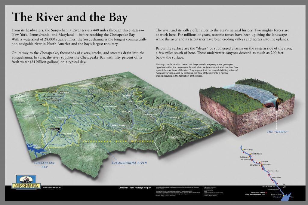
On its journey to the Chesapeake Bay, various rivers, creeks, and streams converge with the Susquehanna as it traverses the terrain. The Susquehanna River is one of the oldest and most important rivers in North America. Flowing 448 miles, the Susquehanna travels through three states: New York, Pennsylvania, and Maryland.The 28,000 square mile watershed is the longest commercially unnavigable river system in North America. The Susquehanna River Corridor provides an excellent glimpse of unique geological land forms. Providing ample opportunity to study a variety of distinct features and examples of geologic processes on display in Lancaster and York Counties.
Geology is everywhere beneath our feet.
The stories of the Susquehanna wind through time, influencing the lives of those who live along its banks and the landscape itself. On its journey, the river provides abundant resources and connects communities, flowing through ancient rock along the way. The Susquehanna is so old that the mountains and valleys formed around it, rather than the river shaping the valleys. The river has witnessed mountain building and erosion as the land was shaped and then reshaped around it. Geologists have looked at the Susquehanna for explanations of the formation of the East Coast. It has always inspired visitors, many attempting to unlock the secrets of the Susquehanna.
Just like the river that cuts through them, every rock has a story to tell along the way. The geology of the Susquehanna River is a leading factor in its unnavigability. Even during times when other sections of the river were considered navigable, the Lower Susquehanna remained untamed. The river itself never served as a successful commercial waterway because of rapids and other obstructions. Despite many wholehearted attempts throughout history, nature has held its claim to this part of the watershed. Over time our communities and transportation routes have developed upon the sculpted landscapes, preserving undeveloped stretches of beautiful scenery and important resources along the watershed.
Every year visitors flock to the Lower Susquehanna to see the many geological wonders to be found on the river. We’ll focus on just a few of the most notable features found in the region.
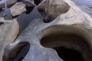
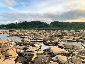
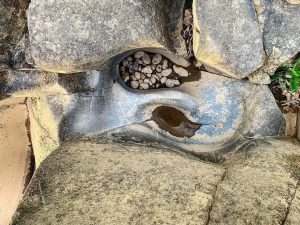
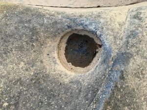
Potholes and Sculpted rock in Falmouth
When the Susquehanna is low the rocks seem to come alive as sculpture-like shaped rocks emerge from the water and stretch across the river below the Conewago Falls in Falmouth, Pennsylvania. Discovered during extremely low water, this otherworldly landscape is one of the most expansive pothole fields uncovered in the United States.
When the York Haven dam was completed in 1904, it was the third largest in the world. The dam follows an existing rock ledge, causing it to cross the Susquehanna river at an angle. Here the river drops 19 feet in 1⁄4 mile. It’s not surprising to find changes in rocks in the riverbed wherever you have a waterfall or otherwise rapid movement in the water. The rocks at the foot of the falls range in size and display various smooth, curvaceous shapes that captivate visitors.
The Conewago potholes and the sculpted rocks found here are composed of diabase, a hard igneous rock, the result of hardened magma emerging during continental drift 200 million years ago. Water and rivers are a major agent of erosion, shaping landscapes over time with the power of water and the sediment it is carrying with it. The potholes were formed as a result of the fast-moving water with the combination of sandy sediment creating underwater vortexes to swirl and carve out the round features in the rock. The igneous rock can withstand the weathering from the water, slowly creating the large smooth boulders… but the hard quartz-sand blasting away with tornado like force did a lot of the carving work, creating a truly unique example of erosion and weathering.
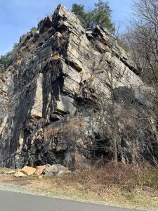
Chickies Rock outcrop in Marietta/Columbia
Chickies Ridge is composed of the uplifted Cambrian Chickies Formation, a mapped bedrock unit in Pennsylvania, New Jersey, and Maryland. It is named for Chickies Rock, a popular rock cliff just north of Columbia along the Susquehanna River. According to the United States Geological Survey (USGS), the summit of the ridge is 587 feet above sea level.
The Chickies Formation is described as a light gray to white, hard, massive quartzite and quartz schist with thin inter-bedded dark slate at the top. Originally the rock was sandstone, but heat and pressure changed the rock into a harder and denser rock. It is a rare metamorphic rock deposit with multiple faults, thrusts, dips, ripples and fossils that can be found throughout the formation. The surrounding rock in the valley was softer compared to the quartzite, leading the softer rock to be weathered and eroded away.
1933 Views of Chickies Rock Anticline
Relative age dating places the Chickies Formation in the Lower Cambrian Period, deposited over 500 million years ago. It was also during this time that the rock was pushed up into an arch. Geologists called this type of fold an anticline.The famous Chickies Rock cliff itself is a classic example. Overlooking the river, Chickies Rock is the largest exposed anticline on the East Coast.
Susquehanna “Deeps”
The Susquehanna Gorge formation starts to take its shape south of Columbia, Pa. Below Turkey Hill, the Susquehanna River is funneled to Port Deposit, MD through a deep canyon-like gorge carved into the ancient rocks of the Piedmont. The river is squeezed through the quarter mile gorge while dropping sharply, roughly 6 feet per mile. On the flat bottom of the 40-mile-long gorge are 6 long spoon-shaped depressions, called the Susquehanna Deeps. These deeps first appeared on Latrobe’s map, derived from his 1801 survey.
During the construction of the Holtwood dam in 1909 some of the deep were exposed, prompting more extensive studies of the depths of all 6 of the Susquehanna Deeps. Some of the deeps are over 100 feet deep, their deepest portions extending below sea level.
Learn more about the geology of the Lower Susquehanna
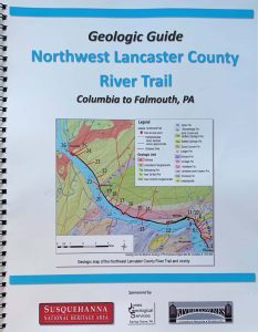
Use the Geologic Guide of the Northwest Lancaster County River Trail (Columbia to Falmouth) to take a geology tour of the area. A great resource to understanding the unique geology of the Lower Susquehanna River along the scenic Northwest Lancaster County River Trail. Available for purchase in our online store or in person at both Columbia Crossing River Trail Center and Zimmerman Center for Heritage.
Want to visit the Conewago Potholes? They are best viewed when water is low during the late summer and early fall. Parking is available at the Falmouth Access.
Want to visit Chickes Rock? View it from the NW Lancaster County River Trail or stand on top the anticline at Chickies Rock scenic overloook. Parking is available at Chickies Rock Overlook.
Experience the Susquehanna while supporting local businesses and SNHA’s work to connect people to the river and its history. For a minimum gift of $50, you’ll receive a unique, one-of-a-kind Picnic Passport Pack that includes a special guidebook with suggestions for great picnic locations, delicious menu options from area restaurants, and engaging information and stories about the river and its many attractions.
Donate online and pick up at one of our riverfront visitor centers. Donations in the form of check or cash can be given at either the Zimmerman Center or Columbia Crossing. Get your Picnic Passport while supplies last!
Though we can’t join you on your outing, we’ll be with you in spirit, as your Picnic Passport package also includes this lovely SNHA-branded picnic blanket, courtesy of Donegal Insurance Group. A free Susquehanna River Water Trail Map & Guide and a variety of restaurant information and coupons. Plus a local sweet treat will complete the package.
We hope you’ll enjoy an excursion on the river this summer while supporting SNHA and local businesses through the Picnic Passport!
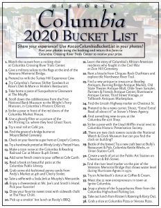
Susquehanna NHA in partnership with Borough of Columbia’s Parks and Recreation Committee has launched a 2020 Columbia Summer Bucket List. We have all been struggling to keep busy and find new fun during the global pandemic. The Columbia Summer Bucket List is here to keep you exploring whether you live in town or your visiting for the day. It’s the perfect time to discover the unique experiences available right here! With over 35 activities featuring nearly 50 Columbia organizations, businesses and landmarks there’s something for everyone!
Keep Your Kids Busy
Columbia has wealth of free and low cost adventures for all types and tastes. We focused on activities that were readily available and safe during the pandemic. Discover new parts of town, beautiful murals, and silly activities. It’s perfect for families. Like #13: Make a train noise at the Columbia & Reading Railroad Car at Manor & 4th Street. Or #3: Pretend to milk the Turkey Hill Experience Cow.
Explore Local History
Dive into Columbia’s history while you’re here. The Bucket List features historic sites and markers like #24: Find the Lincoln Highway marker on Chestnut Street. Pop into the historic district to stroll down the cobblestones to the Wright’s Ferry Mansion. Check off number #21: with a stop at Zion Hill Cemetery where you can learn about Columbia’s African American residents who fought in the Civil War.
Support Small Businesses
It’s also designed to support the Columbia business community. The Bucket List features all kinds of businesses in Columbia that you may not know existed. From the comic book store to the quaint gift shops, you’ll be pleasantly surprised at the variety of shops. Shopping small has a big impact so pick up some Susquehanna glassware, old-fashioned penny candy, or a new-to-you antique while you’re in town. Each stop checks off a bucket list item.
Eat Your Heart Out
Fill your belly too! Columbia Bucket List features old-fashioned favorites like the classic Shifter sandwich to our new obsession: the savory Soul Roll at Cafe 301. Pick your favorite cheesesteak and try some new brews on your quest to conquer the whole list. It’s impossible to leave town hungry!
Download your Bucket List and get started! Or pick up a paper copy at Columbia Crossing River Trails Center: Open Wednesday – Sunday 10 am – 5 pm.
Track your efforts by snapping photos of as many of our summer activities in Columbia as you can and share them to social media using #2020ColumbiaBucketList. Complete a short form on the back of your bucket list and return it Columbia Crossing River Trails Center to claim your prize!
For those that complete at least 15 activities, you will receive this unique sticker! This vintage style crimson and gold sticker captures Columbia’s colors and historic Veterans Memorial Bridge. These 3″ circles are durable, weather resistant, premium vinyl stickers. Slap one on your car, bike, kayak, water bottle or laptop and it will last!
For those that complete at least 30 activities, you will earn the sticker as well as a voucher for a small ice cream cone at Hinkle’s Restaurant. Hinkle’s will scoop your choice of vanilla or chocolate into a cone or dish. Enjoy it as you walk around town or devour it at their classic Ice Parlor & Soda Fountain.
Thanks to Hinkle’s Restaurant for supporting the Columbia Bucket List. We also thank Sticker Mule who has great weatherproof stickers. The Columbia Summer Bucket List was created by the Borough of Columbia’s Park and Recreation Committee in partnership with Susquehanna National Heritage Area. Working together to share Columbia’s historic, scenic, and recreational stories and experiences with residents and visitors and support our local business community.
River Roots is Susquehanna NHA’s blog series featuring history from York and Lancaster Counties that showcases the Susquehanna River’s historic, cultural, and natural resources contributions to our nation’s heritage.
This month SNHA is uncovering the details of Benjamin Henry Latrobe’s 18-foot long survey of the Lower Susquehanna River. Although Benjamin Latrobe is remembered as an accomplished architect, in the Susquehanna NHA we honor him for his amazing map of the Lower Susquehanna.
Susquehanna, The Navigable?
Near the turn of the 19th century, water-based transportation was essential to civilization. With no automobiles or trains, land transportation was limited to horse and foot. Across the new United States, surveyors and map makers were seeking to find connective water routes – like the Lewis & Clark Expedition that started in 1803. The Susquehanna’s connection to the Chesapeake Bay made it an obvious target for commerce.
The Lower Susquehanna was swift and rocky. The Susquehanna was only navigable downriver to Columbia, even during spring freshets. There wheat, beef, coal, lumber, and other goods were unloaded and carried via wagon to Philadelphia. Downriver from Columbia, craggy metamorphic ridges rise up between 200 and 500 feet above the water in what is called the Susquehanna Gorge. At the bottom of the gorge, the river was dominated by huge rocks protruding above the waterline. This is no small obstable to overcome as the gorge runs from Turkey Hill to Port Deposit, a distance of nearly thirty miles.
Benjamin’s Survey
In 1801, Pennsylvania Governor Thomas McKean appointed Latrobe surveyor and assistant to his uncle, Frederick Antes, as authorized by a 1799 state statute providing for navigation improvements to the Lower Susquehanna River south of Columbia. Latrobe and Antes represented Pennsylvania in a joint venture with the Susquehanna Canal Company, a Maryland entity building a canal from the Pennsylvania border to tidewater.
With his uncle’s death in September 1801, Latrobe assumed control of the Pennsylvania portion of the project, working with his Maryland partners. Latrobe surveyed the river in October-November 1801 with the help of two assistant surveyors, chainbearers, axemen and canoemen. He completed his map over the winter, including a proposed new route for navigating the rocky river. Latrobe presented his work to the governor in Lancaster (then Pennsylvania’s capital) in March 1802 and lobbied the legislature for project funding. His efforts were successful, and the navigation improvements were completed soon after.
Latrobe’s Susquehanna survey map represents a rare profile of the physical features of a region just beginning to feel the impact of agricultural and commercial development. This landscape has changed drastically since Latrobe’s time, with 60 percent of the river below Columbia now submerged by reservoirs from three 20th century dams. Latrobe’s original 18-foot long survey of the Susquehanna was before Congress for consideration of internal improvements when it was destroyed during the Capitol’s burning by the British in 1814. His personal copy of the 1801 survey, shown below, now resides in the collections of the Maryland Historical Society. A full-size reproduction of this survey copy is on public display at the waterfront pavilion of Susquehanna NHA’s Zimmerman Center for Heritage.
Benjamin’s Map
The river rapids shown by Latrobe reveal that the river’s steepest gradient is near its mouth. Such conditions exist in most of the great African rivers, but they are not found in any other river on our Atlantic seaboard. These circumstances made upstream travel almost impossible. Even downstream travel was made only by arks and rafts which were usually dismantled at their destination and sold as lumber. Latrobe sought a route to take boats northbound but there were many challenges.
Most narrow part of the southern half of the Susquehanna River is at McCall’s Ferry, modern day York Furnace. In Latrobe’s survey it was listed as 16 perches, or 264 feet wide. In 1815, when a bridge was built across the river there it was 360 feet long. After the Holtwood Dam was constructed, the river was widened by the backed-up water, but the spot is still less than ¼ mile wide or 1320 feet. Near this narrow spot in the river were also many deeps.
At a place known as The Neck, Latrobe dropped a 180-foot line with a lead weight, and it didn’t hit the bottom. The weight also didn’t hit bottom along the eastern shore at McCall’s Ferry. During the construction of the Hotlwood Dam (1909), Conowingo Dam (1925), and Safe Harbor Dam (1930), many deep gashes were found in the riverbed. These underwater canyons descend below the surface as much as 200 feet and stretch up to two miles in length. Latrobe was likely puzzled by his observation of such deep water since the levels elsewhere were very low. Latrobe was able to walk across the river south of Turkey Hill. He wrote “I walked dry shod across the rocks from Savers bottom to the channel on the Eastern side, which was then about 100 feet wide.” In the end, Latrobe laid a channel to allow southbound traffic in all seasons. Even with blasting obstructions and clearing a narrow channel, the Susquehanna was still very hazardous.
Enduring Features
Use the slider image above to compare Latrobe’s map to modern Google Earth. Latrobe’s ability to capture the shape and scale of the river with accuracy is impressive. Although many of the river’s islands shown by Latrobe were submerged because of the construction of the hydroelectric dams, some of the islands and their names still endure. South of the Norman Wood Bridge is the Bear Islands. Latrobe described their features as “They are high Rocky masses of great extent, covered chiefly with pines” that “rose from 20 to 30 feet above the water.” Just north of the Pequea Creek outfall is Weise Island. On Latrobe’s Map this is labeled Stoner’s Island and has two small structures on it that may have been part of the local ferry operation. Mud Island near Columbia remains the same while Reed Island, south of Pequea, has shrunk dramatically. Many of the islands are now under the river’s flow which has skewed our vision of the river’s natural state.
The sheer cliffs and peaks along the riverfront also remain. These are helpful to orient the 1802 map with modern maps or other historic maps. Latrobe identified:
• Neal’s Point now Hawk Point Overlook
• Neck Mountain now Pinnacle Overlook
• House Rock now House Rock Overlook
• Raven’s Nest now Safe Harbor Overlook
• Turkey Hill now Turkey Hill Overlook
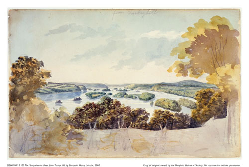
Although the goal of the survey was to increase navigability of the Lower Susquehanna to the tidewater some of the notes and features expand our understanding of early American life. Latrobe identifies over two dozen riverfront homesteads and farms. There are six ferries listed as well as three sawmills. There’s also a slate quarry near Peach Bottom and a fishery north of Pequea Creek. One enduring structure is “Col. Tritt’s” home, now the Zimmerman Center for Heritage, which still stands as shown on Latrobe’s map, just below “Tritt’s Islands.” Latrobe also made pencil sketches and watercolors along his journey, capturing a scenic natural area just beginning to develop as a corridor of culture and commerce.
Views of Susquehanna from foot of falls above Columbia
George Stoner’s on Pequea Creek, Burkhalters Ferry
The Susquehanna River from Turkey Hill
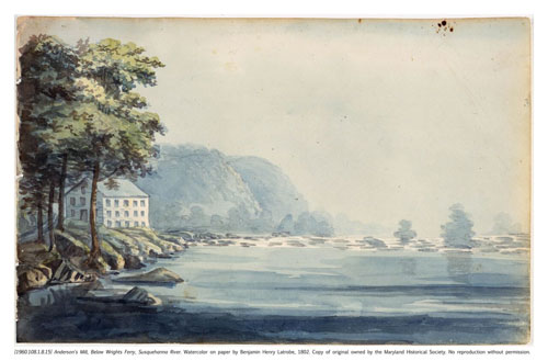
Anderson’s Mill Below Wright’s Ferry, Susquehanna River
Latrobe’s survey resulted in the blasting of rock to create a 40-foot-wide channel but it would be thirty years until canal companies would make the river easily navigable. The Susquehanna & Tidewater Canal finally carried cargo on the west side of the river between Havre de Grace, Maryland and Wrightsville, Pennsylvania in 1840. Boats were then towed along the Columbia-Wrightsville Bridge and entered the Pennsylvania Main Line Canal which traveled up the east side of the river to north of Harrisburg. The advancement of land transportation via railroads would eventually end the age of canals and with it the quest to make the Susquehanna navigable.
The Latrobe map was pulled from the archives and used by Pennsylvania Water & Power Company as it prepared for construction of the Holtwood Dam in 1909. The map served as a guide to subdue the river just as it had been 100 years earlier. Today, the Latrobe map shows us the power of people to affect the environment, as well as the power of nature to resist those changes. The Susquehanna Gorge has retained its mysterious deeps, its sheer cliffs, and its rocky bottom despite two centuries of human manipulation.
Learn More
Brubaker, J., 2002. Down The Susquehanna To The Chesapeake. University Park, Pa: Pennsylvania State Univ. Press.
View the Susquehanna! Go to the Overlooks noted on Latrobe’s map and see what the river looks like today. Can you imagine where all the rocks, rapids, and homesteads were 200 years ago?
With Lancaster and York Counties entering new phases of PA’s COVID-19 response, Susquehanna National Heritage Area is re-opening our two visitor facilities along the Susquehanna River and launching our second season of River Discovery Boat Tours. York County entered the GREEN phase on June 12th and Lancaster County enters the GREEN phase on June 26th . Here’s what to expect for each facility and our boat tours during re-opening:
ZIMMERMAN CENTER FOR HERITAGE – SNHA owns and manages this historic 18th century riverfront home south of Wrightsville in York County, with visitor services, exhibits, and galleries. With York County in GREEN, the Zimmerman Center re-opened to the public onFRIDAY, JUNE 19TH with regular hours, Tuesday-Sunday, 10am-4pm. New procedures are in place for visitors and staff to comply with CDC and PA Department of Health guidelines. All inside visitors to the building are required to sign-in with contact information. Self-guided tours of the first floor are offered, with no full-house tours or inside programs. Masks are required for visitors and staff inside the building, with disposable masks available.
COLUMBIA CROSSING RIVER TRAILS CENTER – SNHA manages this riverfront visitor education center in Columbia River Park in Lancaster County for the Borough of Columbia, including visitor services, maps and guides, exhibits, programs, and facility rentals. With Lancaster County entering the GREEN phase, Columbia Crossing re-opens to the public on FRIDAY, JUNE 26th, with revised hours, Wednesday-Sunday, 10am-5pm. Restrooms are open with outside access, 6am-6pm daily. All activities will comply with CDC and PA Department of Health guidelines. Masks are required for visitors and staff inside the building, with disposable masks available.
RIVER DISCOVERY BOAT TOURS – SNHA will launch our 2nd season of free pontoon boat tours from the Zimmerman Center on Friday, July 3rd. Tours will be offered Friday/Saturday/Sunday and frequency increased from 3 to 4 per day. Registration will be limited to 8 passengers per tour instead of 10 to allow for social distancing. The boat and equipment will be sanitized between tours. Similar to last year, pre-registration will be required online, but no walk-ons will be permitted to fill no-show seats. All check-in will be done outside in the waterfront pavilion, with Covid-19 screening questions, temperature checks, and face masks required. Disposable masks will be provided to passengers as needed. Online registration for boat tours will be available at this website link starting MONDAY, JUNE 15th: https://susqnha.org/programs/boat-tours/
We look forward to welcoming the public back to the Zimmerman Center, Columbia Crossing, and our River Discovery Boat Tours. For further updates and other information about SNHA and our facilities, programs, and projects, please visit our website and social media pages at the following links:
Black Lives Matter – Yesterday, Today, and Tomorrow
In 2020, America once again faced the reality of systemic racism and violence against Black Americans in the
wake of George Floyd’s horrible murder by a police officer in Minneapolis. The passionate protests and calls for change flowing from this tragedy roiled people and places across the nation and the world. This was right and proper, and it wasn’t new. Many protested the hate and hostility inflicted on people of color in our country long before Mr. Floyd’s death, including here at home. Such activism has been necessary because our region shares the same history and pervasiveness of racism as the rest of America, and has done so for a very, very long time.
When the Dritt Mansion, now SNHA’s Zimmerman Center for Heritage, was constructed along the Susquehanna River in York County about 1750, slavery was legal in Pennsylvania, with over 6000 Black Americans in bondage. Slavery was not abolished here until 1780, and then only phased out, with many still enslaved well into the 19th century. For over thirty years after our area and people played a key role in securing freedom and independence during the Revolutionary War, Black Americans were still enslaved here, including at the Dritt Mansion itself.
We should be proud of those who strived for racial justice in the two centuries that followed. Black businessmen like William Goodridge, William Whipper, and Stephen Smith, Quakers like the Wrights and Mifflins, and many lesser known Underground Railroad supporters who assisted those escaping slavery. We should be proud of the Christiana Resistance of 1851, when Black and non-Black Lancaster Countians clashed with a Maryland enslaver to ensure freedom for his fugitive former captives. We should be proud of those who fought to end slavery in the Civil War and abolitionists like Thaddeus Stevens who helped advance equality for Black Americans. We should be proud of local citizens who strove for justice in the civil rights era, desegregating Lancaster pools and facing racial strife in York in the 1960s. And we should be proud of the racial justice movement today.
The very need for such heroes and actions throughout our history demonstrates one thing we should not and cannot be proud of – the persistent and still-prevalent racism and injustice experienced by people of color in our community. Since our founding in 2001, SNHA has sponsored projects highlighting the importance of Black Americans in our region’s history and hosted programs that bring young people of color to the river for fun and learning. But we have not done nearly enough. As we embrace, learn from, and take part in America’s historic racial justice movement, we must, and will, stand against racism and for racial equity, diversity, and inclusion – in our storytelling, our community projects, our partnerships, and our workplace.
Since 2020, SNHA has engaged our staff and Board to assess and update our policies and practices to ensure justice, equity, diversity, and inclusion in our programs, projects, and leadership. SNHA staff have participated in excellent forums on these issues through the National Park Service, Alliance of National Heritage Areas, and other partners. We will apply this learning and other resources and guidance to make our organization better.
In 2022, SNHA completed our National Heritage Area Management Plan to guide our work over the next decade. As we implement the plan, we’ll ensure that the advisory groups, partners, consultants, and communities we work with are diverse and inclusive and that contributions from people of color are heard and addressed. Our current inclusive storytelling project focused on key people, places, and events important to Black lives and Black history in our National Heritage Area will provide an essential framework for this work in the years ahead.
We look forward to working with our community and partners to ensure that our organization promotes racial justice and celebrates cultural diversity.
Mark N. Platts, President
Originally posted June 2020 / Updated August 2023
River Roots is Susquehanna NHA’s blog series featuring history from York and Lancaster Counties that showcases the Susquehanna River’s historic, cultural, and natural resources contributions to our nation’s heritage.
Iron was essential in building America. In the 19th century, iron was used in railroads, boats, ships, buildings, and steam engines among other items. Before steel could be easily manufactured, iron was the most popular metal. A small but mighty stretch of iron furnaces could be found along the Susquehanna River in Pennsylvania in the vicinity of Columbia, Marietta, and Wrightsville . In the latter half of the 19th century, eleven iron furnaces were operated between Columbia and Marietta. The industrial complex was expansive enough to rival the Iron City of Pittsburgh, earning it the title The Pittsburgh of the East.
Anthracite Iron Revolution
In the early 1800s, the iron industry went through an important transition from pioneer ironmasters to skilled industrialists. Early iron masters toiled with their workers. To be successful they had to take a real interest in the details of their work, including solving metallurgical problems and transportation logistics. They also had to solve financial problems without the aid of commercial banks. By 1850, progress in technology, banking, and transportation changed the iron industry. Ironmasters could oversee the business operations and hire knowledgeable skilled laborers to lead the furnace operation.
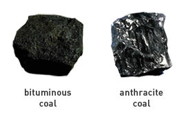
The most important technological change for the Susquehanna River region involved developing the use of anthracite coal in creating pig iron. Charcoal was the standard fuel for combustion but depended on the availability of wood, which was less readily available in the Lancaster area. Anthracite coal was readily mined in Pennsylvania but was too dense to burn productively in blast furnaces. It was so dense it was referred to as ‘Stone Coal.’
The addition of hot air was all that was needed to promote combustion of the dense anthracite coal. The hot blast method was developed in Britain and was then brought to Catasauqua, Pennsylvania. Knowledge of this development spread quickly, which may have led to the construction of the first Columbia area furnace, Shawnee Furnace, in 1844. Just over a decade later in 1856, Lancaster County produced ten percent of all anthracite iron in United States.
Finding the Perfect Location
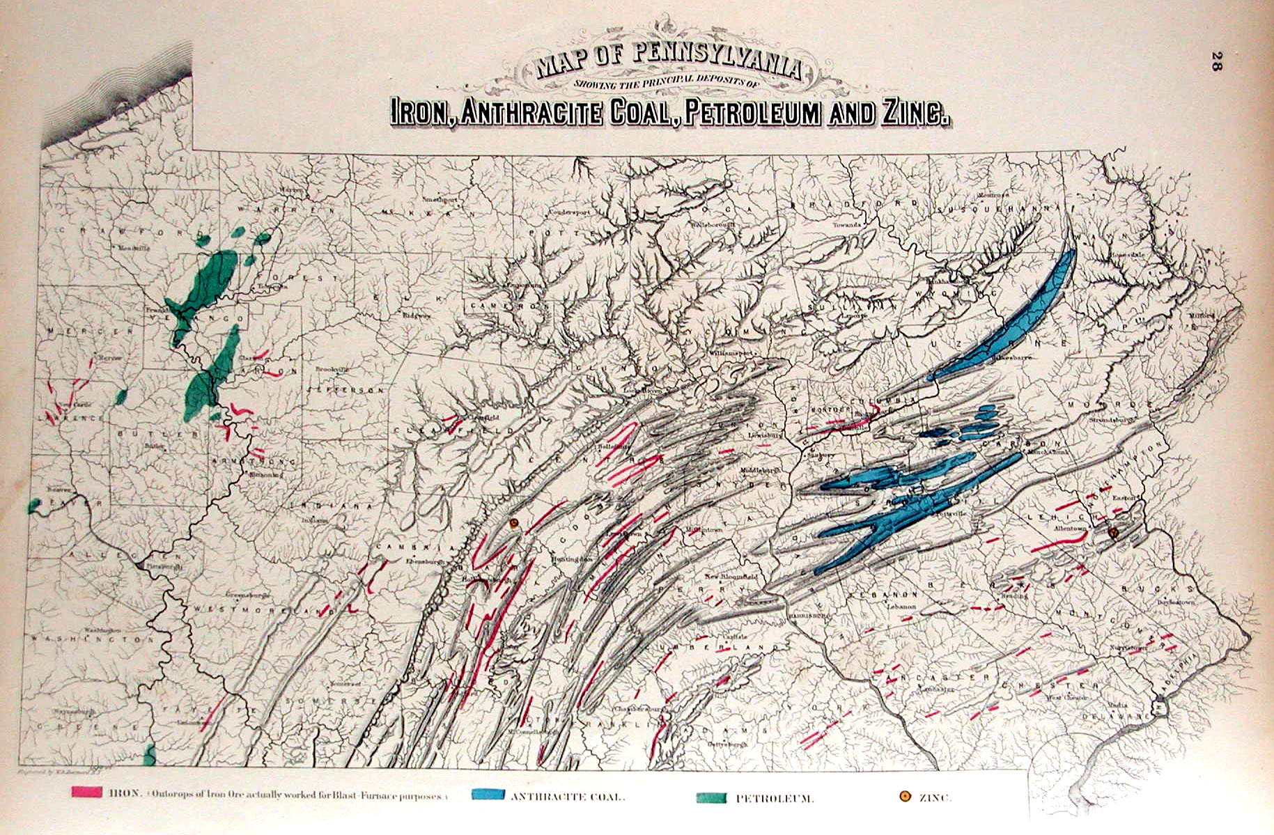
Harold Cramer, “An Overview of Pennsylvania Mapping Circa 1850 to 1900”
Compared to Pittsburgh located at the foot of the Allegheny Mountains, the anthracite furnaces of Lancaster County were located near similar geologic conditions. Nearby raw materials like limestone and iron ore inspired savvy entrepreneurs to set up blast furnaces. The nearby flowing water of the Susquehanna could help cool the furnaces and power operations. The towns of Columbia and Marietta were well established and could supply a steady workforce of skilled and unskilled labor.
Like the three rivers in Pittsburgh, the Susquehanna River provided a transportation hub that allowed for the distribution of goods and the success of the pig iron furnaces, allowing for a booming industry. Transportation infrastructure was critical to success. Those businesses and industries along existing or newly constructed routes could easily receive raw materials and ship finished products. For the iron industry in Pennsylvania, canals and railroads were essential. The Eastern Division Canal and the Union Canal in Pennsylvania brought coal from places like Scranton, Wilkes Barre and Pine Grove, and was delivered to Columbia for the nearby furnaces. Much of the pig iron was then shipped east via the railroad to Philadelphia where it was worked and forged into usable products.
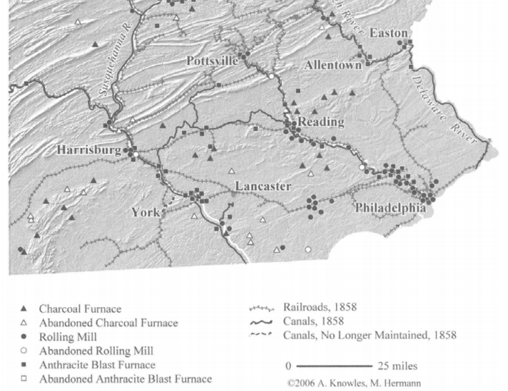
Ironworks and Transportation in Southeastern Pennsylvania, 1842-1858. From Knowles, Anne Kelly, and Richard G. Healey. “Geography, Timing, and Technology: A GIS-Based Analysis of Pennsylvania’s Iron Industry, 1825-1875.”
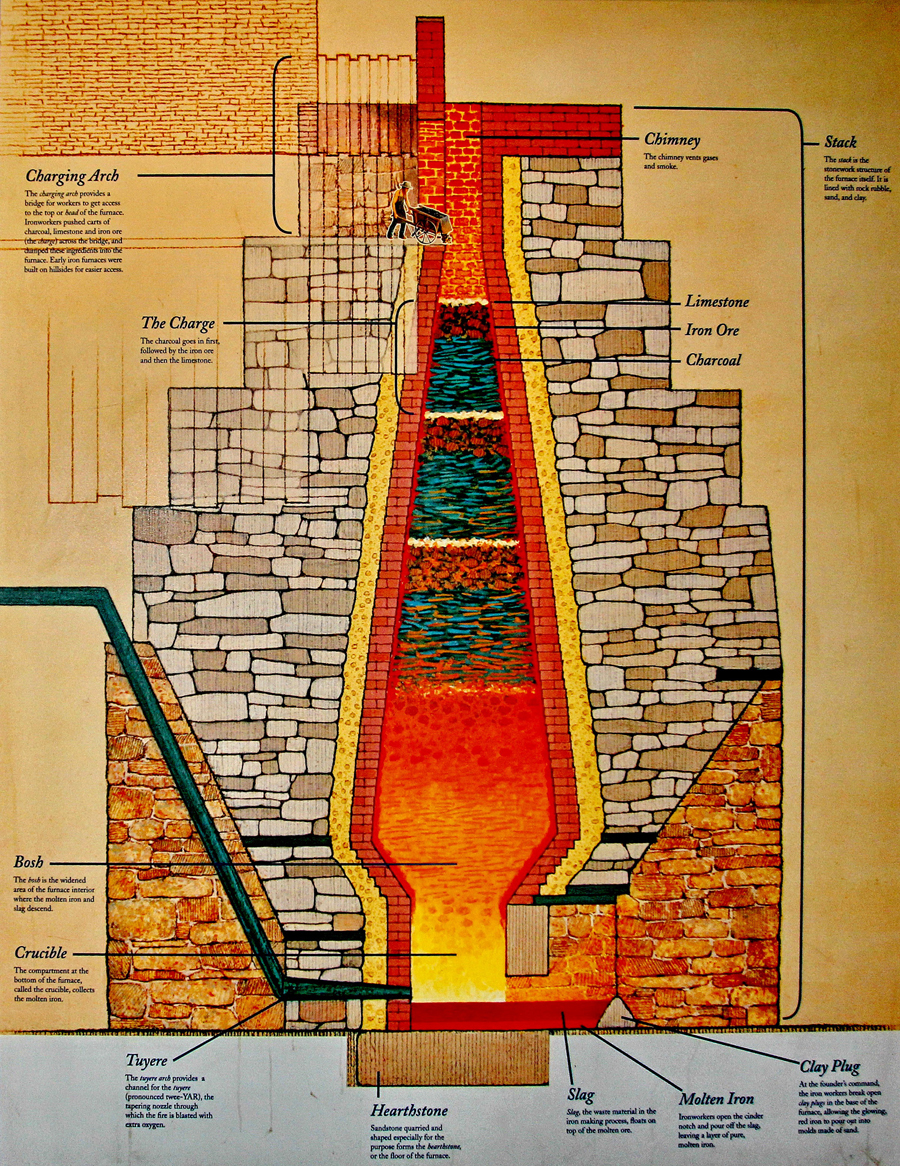
Making Pig Iron
Mechanics of the Cornwall Iron Furnace in Lebanon PA.
Iron ore are rocks from which metallic iron can be extracted. It is extracted through a blast furnace into iron bars or pig iron. The pig iron was then sent to forges where it was worked into wrought iron and, later in 19th century, steel. Pig Iron is produced directly in a blast furnace. Layers of limestone, iron ore, and anthracite coal were dumped into the top of the furnace. Outside the furnace, hot air was made by blower engines powered by water or steam. Hot air was then blasted into the bottom of the furnace which forced the coal to ignite and begin a chemical reaction.
The reaction created molten iron as well as slag. Slag is the waste product of impurities that were removed from the iron ore in the blasting process. The molten slag sits on top of the molten iron so it can be easily poured or channeled out of the furnace. The molten iron flows from the furnace into a channel consisting of large molds in a sand floor. The flow of molten iron continued into smaller molds attached to the sides of the large ones. The arrangement of smaller and larger molds reminded ironworkers of pigs (the smaller molds) spread at the sides of sows (the larger molds). Thus, ironworkers called the bars made in smaller molds “pigs,” the ones in larger molds “sows,” and the overall product “pig iron.”
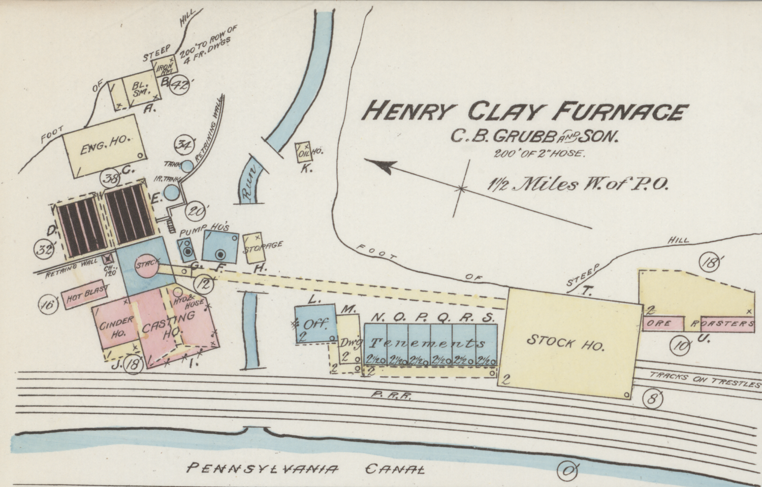
1886 Sanborn Map showing the complex structures in the Henry Clay Furnace operations in Marietta.
Little Pittsburgh in Lancaster County
In the area between Marietta and Columbia eleven furnaces operated between 1845 and the end of the century. It’s important to note that the furnaces did not operate as a lone stack. There were many connected and ancillary buildings to keep the hot blast furnace flowing. It was common to have a casting house, stock house, ore roasters, engine house, as well as houses for the workers. Let’s follow the development and operations of just one of the furnaces: the Chickies Furnace. It is a great example of how iron industry developed and changed quickly in the late nineteenth century. It was the longest operating and most successful furnace in the Columbia-Marietta area.
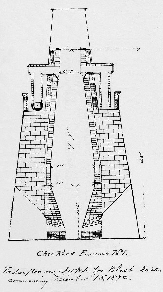
Chickies No. 1 Blast Furnace, circa 1870.
Chickies No. 1 was constructed in 1845 by Henry Haldeman, who in that same year turned it over to his sons, Samuel and Edwin. Furnaces built by the Haldemans were notable for their advanced technology. Samuel shared information and diagrams of the Chickies No. 1 furnaces in a national journal. Chickies No. 1 went into blast in 1846 and was never out of blast for long periods thereafter. In 1848, it produced 2,464 tons of iron. Letters show us that Samuel Haldeman studied the furnace design and made frequent improvements. In one letter, he wrote that the furnace was built to produce forty ton of pig iron a week but in six days had made seventy-two tons. It was the most productive and technologically advanced of the furnaces on the floodplain.
Chickies No. 1 was originally 32′ high with an 8′ bosh, but the furnace underwent a number of remodeling projects until it was completely rebuilt in 1886. At that time, the stone stack was removed and replaced with an iron cylinder lined with firebrick and set on a mantle ring supported by six cast iron columns. A separate concrete foundation supported the lower bosh and crucible. The resulting furnace was 65′ high with a 12′ bosh and an annual capacity of approximately 17,000 tons, thirty times its output in 1848. All new blast machinery, stoves, and boilers were installed, and a new Romanesque-style brick cast house replaced the earlier one. Special rail connections for moving materials between the two Chickies furnaces were constructed.
The principal ores used at the Chickies furnaces were brown hematite from Chestnut Hill located six miles east and magnetic ores from the Cornwall mines. The pig iron produced was sold under the brand name “Chickies” through agents in Philadelphia, New York, Baltimore, and Pittsburgh. The furnace went out of blast permanently in 1899 and was dismantled not long thereafter. Ten other furnaces operated between 1840 and 1930. To explore the history of each operation visit Rivertownes.org.
Technology Advances Ending Iron Production at Chickies
Just like a change in technology allowed for booming blast furnaces, it was also what ended the era. Between 1840 and 1880 the iron industry experienced profound technological changes, including a shift in fuel from charcoal to anthracite coal and then to bituminous coal and coke. During the 1850s furnaces fueled by anthracite superseded charcoal furnaces. By 1875, furnaces fired with bituminous coal and coke supplanted anthracite furnaces. Bituminous coal allowed for better efficiency and reduced costs for Ironmasters. The iron industry at Chickies was able to produce pig iron for some steel uses and cast-iron products through the 1880s despite the popular fuel change.
In the 1880s, steel mills began to manufacture iron in iron furnaces and then converted the iron into steel. From raw iron ore to steel, the process was under one location and operation. The ironmasters of Columbia and Marietta were quickly unnecessary for steel manufacturing. In 1892, the output of America’s steel mills first surpassed iron production. Most of the furnaces along the river were dismantled or stopped operating by 1899 and the Pittsburgh of the East faded into history.
Learn More
You can see the remains of the iron furnaces today, most of which can be found along the Northwest Lancaster County River Trail between Columbia and Marietta. Find a map here.
Run your own furnace! The BBC has created an interactive Blast Furnace Animation. There’s also an option to ‘Build It,’ which allows you to construct all the parts of the furnace stack.
Resources
Rivertownes PA USA: Iron Furnace History: Marietta. Retrieved May 20, 2020, from http://www.rivertownes.org/
Bining, Arthur C. “Early Ironmasters of Pennsylvania.” Pennsylvania History: A Journal of Mid-Atlantic Studies 18, no. 2 (1951): 93-103. Accessed May 27, 2020. www.jstor.org/stable/27769194.
Knowles, Anne Kelly, and Richard G. Healey. “Geography, Timing, and Technology: A GIS-Based Analysis of Pennsylvania’s Iron Industry, 1825-1875.” The Journal of Economic History 66, no. 3 (2006): 608-34. Accessed May 27, 2020. www.jstor.org/stable/3874854.
Overman, Frederick. The Manufacture of Iron. United States: University of Michigan Library, 2012.
Stapleton, Darwin H. “The Diffusion of Anthracite Iron Technology: The Case of Lancaster County.” Pennsylvania History: A Journal of Mid-Atlantic Studies 45, no. 2 (1978): 147-57. Accessed May 27, 2020. www.jstor.org/stable/27772508.
River Roots is Susquehanna NHA’s blog series featuring history from York and Lancaster Counties that showcases the Susquehanna River’s historic, cultural, and natural resources contributions to our nation’s heritage.
This week we explore dugout canoes on the Susquehanna River. Long before powerboats and jet skis, before mule-drawn canal boats, and before Anderson’s, Wright’s and Cresap’s ferries, dugout canoes were the favored way of navigating the Susquehanna’s shallow waters.
Dugout Canoes on the Susquehanna
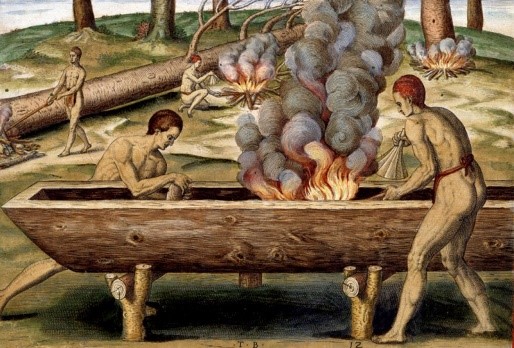
Indians Fishing, Theodor de Bry engraving after John White watercolor, c.1590. This hand-colored engraving is from The Briefe and True Report of the New Found Land of Virginia…, Thomas Hariot, 1588. (The Mariners’ Museum Library, Newport News, Virginia)
Unlike the birchbark canoes used by many northern American Indians, dugouts were heavy, slow, and unsuitable for long distance travel. But the swift, rocky, Susquehanna was not suited for travel in more fragile birchbark canoes, and birch trees with suitable bark were not found here. So, the lower Susquehanna’s native peoples relied on their network of footpaths to traverse the land. However, for fishing and carrying cargoes of meat and hides, and people, across the river, dugouts were ideal.
Dugout canoes have been used by indigenous peoples worldwide for thousands of years. Specimens recovered in the northeast United States have been found dating as far back as 6,000 years before the present. They were undoubtedly being constructed thousands of years earlier.
Based on historic accounts, most dugouts were less than 20 feet long, but some were reported to be 50 feet or larger. In the southeastern United States, 16th century Spanish explorer Hernando De Soto encountered dugouts on the Mississippi River carrying 75 to 80 warriors with 25 paddlers on each side. These vessels may have approached 100 feet in length. Some southeastern dugouts were painted, and some were carved with designs of snakes and fishes. Dugouts from the Mississippi Valley sometimes had decks, seats, or awnings. Early English reports from the Chesapeake mention canoes 40-50 feet long able to carry about one passenger per foot of length. English explorer John Smith reported some in the Chesapeake as being 3-4 feet deep.
Mud Pond dugout on display at the State Museum of Pennsylvania, Harrisburg
Nearly 20 dugout canoes have been found in bogs and lakes in Pennsylvania, primarily in the Pocono region. No archaeological evidence of dugouts has been found along the Susquehanna, but Smith’s journal of his travels on the Chesapeake Bay does mention Susquehannock “canowes”:
“Five of their chiefe Werowances came boldly aboord us to crosse the Bay for Tockwhogh, leaving their men and Canowes…”
We assume the canoes were dugouts, as he describes the canoes of another, distant tribe as being “small boats, made of the barkes of trees”. We can also make the argument that the Susquehannocks didn’t paddle their canoes from their town at today’s Washington Boro to the mouth of the Susquehanna. Paddling down the Susquehanna would be possible, but paddling back through rapids, or portaging around them, would have been an ordeal. Walking, at least upriver, would be faster, and leaving their dugouts at the bay wouldn’t make sense. Finally, Smith makes no mention of them arriving to the river’s mouth in canoes.
Dugouts were typically left where they were used, be it lake or river, and the Susquehannock frequented the Bay, so no doubt they kept dugouts along its shores for their use. There is evidence to suggest that they may have been sunk with rocks when not being used to keep them from drying out and cracking, and perhaps to hide them from potential thieves.
Making the Dugout
Most simply put, a dugout canoe is just a hollowed-out log. But the process for making one isn’t quite so simple. Consider the work involved. First, tools for the job need to be fashioned. Although by the time the Susquehannock tribe arrived on the lower Susquehanna, metal tools were being obtained from European traders, stone tools were still in use. Several types of tools may have been used in dugout canoe construction – axes, handled adzes, hand adzes, and smoothing stones, for example. For a cutting tool, the proper type of stone (meta-basalt and meta-rhyolite work well) must first be found. Working the rough stone into a sharp tool required flaking, pecking, grinding, and polishing to the proper shape and edge, a process that could take in excess of eight hours. Axes and adzes had to be hafted onto a wooden handle, a technical process in itself. Next, a tree, of the proper size and type (commonly, white pine), must be selected. Felling the tree could be accomplished by chopping, but burning a controlled fire at its base may have required less labor.
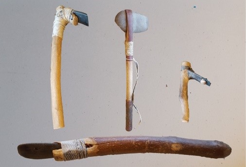
Tools used in dugout canoe construction (Clockwise from bottom: hafted scraper, adze, hand axe, finishing adze)
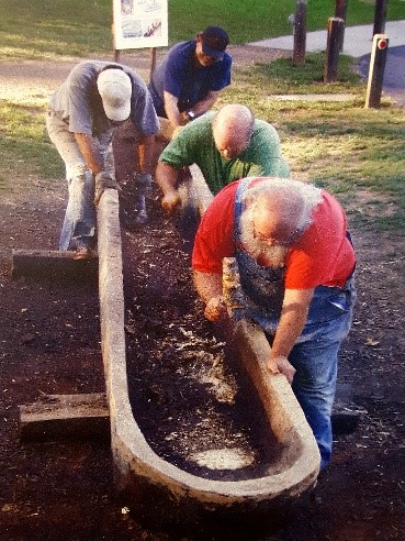
In order to better understand the effort, tools, and techniques required to create a dugout canoe, archaeologists from the Pennsylvania Historical and Museum Commission (PHMC) have employed experimental archaeology to produce several full-size replicas using the same tools and techniques American Indians used those many years ago. One of the dugouts is a popular annual attraction at the Pennsylvania Farm Show and has also been on display at SNHA’s Columbia Crossing River Trails Center. The archaeologists based their design on a dugout discovered in 1935 by a group of boys in Mud Pond near Pleasant View Summit, in eastern Luzerne County, and donated to the State Museum of Pennsylvania in 1968. The dugout, dating to circa 1250 AD, is now exhibited in the museum’s Anthropology Hall.
The archaeologists were aided by early descriptions and illustrations of Native American vessels, including the well-known 16th century accounts by British explorers John White and Arthur Barlowe of dugout canoes used in what would become Virginia and North Carolina. Both White and Barlowe describe a process of burning and scraping with shells to fashion dugouts. Other than for cutting down the tree, they do not reference the use of stone axes or adzes. In his report of the 1584 reconnaissance of what is now coastal North Carolina, Arthur Barlowe described the process this way:
“Their boates are made of one tree, either of Pine, or of Pitch trees: a wood not commonly knowen to our people, nor found growing in England. They have no edge tooles to make them withall…they burne downe some great tree, or take such as are winde fallen, and putting myrrhe [sic], and rosen upon one side thereof, they sette fire into it, and when it hath burnt it hollowe, they cutte out the coale with their shels, and ever where they would burne it deeper or wider, they laye on their hummes, which burneth away the timber, and by this meanes they fashion very fine boates, and such as will transport twentie men.”
The manner of makinge their boates, Theodor de Bry engraving after John White watercolor, c.1590. This hand-colored engraving is from The Briefe and True Report of the New Found Land of Virginia…, Thomas Hariot, 1588. The Mariners’ Museum Library, Newport News, Virginia)
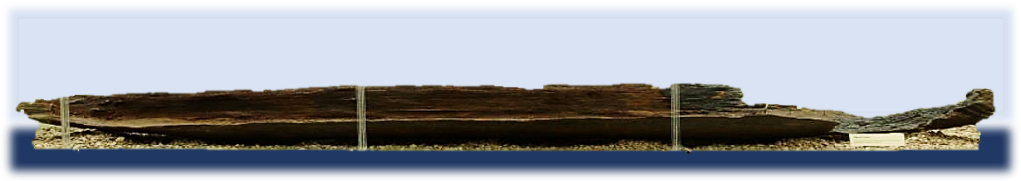
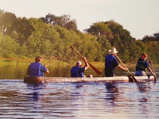
For the replica, a 20-foot long white pine log measuring nearly three feet in diameter was secured. The log came from a tree in Michaux State Forest that had been blown down in a storm. Over the course of seventeen days a crew of at least three people worked six to eight hours a day to complete the task. Each morning, a fire was started the length of the dugout and allowed to burn for two to four hours. Clay was applied around the fire to control the burn. When the fire was extinguished, the charred material was completely removed by scraping with beveled pieces of wood and finally with the stone adzes. The worked progressed slowly, with less than one inch of material being removed each day. After the interior was finally roughed out, it was rubbed with pieces of sandstone to reduce splinters and increase comfort. The last step was to apply a coat of pine tar mixed with hot wood ash to serve as a sealer. The maiden voyage for the dugout came on October 2, 2005, when a crew of four archaeologists paddled down the Susquehanna from Fort Hunter to City Island in Harrisburg. They described the canoe as stable, but not agile. Although it took some work to get it moving, once underway its momentum kept it going without undo effort.
PHMC archaeologists making replica dugout (left) and taking on its maiden voyage. (right)
Dugouts after European Arrival
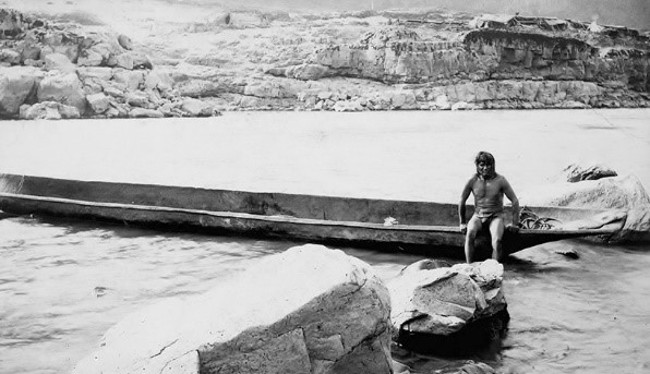
Native American and dugout on the Columbia River, 1897. (Library of Congress)
Dugout canoes were so sturdy, dependable, and well-suited to their purpose that the coastal Indians were slow to adopt white settlers’ planked boats. With a full complement paddling, a canoe could overtake or pull away from an English boat of comparable size under oars. Additionally, because of their narrow beam and shallow draft, canoes could easily ply waters closed to many of the small crafts used by the English. Colonists quickly adopted the canoe and even adapted it to sail. On the Susquehanna, John Wright’s ferry operation used dugout canoes lashed together to transport wagons across the river, and dugouts continued to be made and used by European settlers well into the 1800s.
To Learn More
Check out the The 2005 Pennsylvania Dugout Canoe Project. This detailed PowerPoint Presentation shows images and details about the tools and process used by the Pennsylvania Historical & Museum Commission.
Resources
Carr, Kurt W., et al. The Pennsylvania Dugout Canoe Project Pennsylvania Historical and Museum Commission Bureau for Historic Preservation, 2006
Partner Spotlight: Lancaster County Solid Waste Management Authority
We’ve all become more grateful for the outdoor recreation spaces since the global pandemic shuttered our favorite restaurants, businesses, and community spaces. Maybe you’ve never visited these trails before, or you’ve just recently realized their significance. Outdoor recreation spaces, natural habitats, preserves, and trails have greatly expanded along the Susquehanna over the past 20 years. At SNHA, we work with great organizations to grow outdoor recreation opportunities and preserve our natural and cultural heritage. We want to share with you our SNHA partners and their great contributions to our Heritage Area. Partners bring funding support, unique talents, and a collaborative passion for the river.
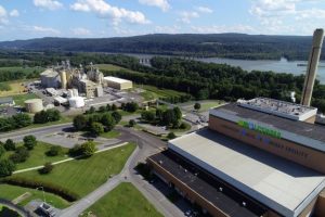
The Lancaster County Solid Waste Management Authority (LCSWMA) has committed to enhancing the recreational opportunities and quality of life in areas where LCSWMA has major facilities. There are two LCSWMA facilities along the Susquehanna River in Lancaster County, which include the Lancaster Waste-to-Energy Facility in Bainbridge that combusts waste to make electricity for our community and the Frey Farm Landfill in Manor Township. LCSWMA has made a proactive commitment to the river and its assets for over a decade. SNHA’s ten-year partnership with LCSWMA has focused on enhancing the heritage, outdoor recreation, and environmental qualities of the Susquehanna River as it flows through our region. LCSWMA’s financial investment and professional support for SNHA’s vision and mission has been vital for our efforts to connect people to the river and its history. With LCSWMA as a partner, SNHA has been able to promote the heritage and economic vitality of the Susquehanna River corridor.
Lancaster’s Riverfront Projects
LCSWMA owns over 1,000 acres of land, most of which is along the Susquehanna River in Lancaster County. The land is used to manage waste in a sustainable and an environmentally safe manner, as well as utilized to increase the livability of our community. Let’s explore some of their projects along Lancaster County’s riverfront.
Northwest Lancaster County River Trail – LCSWMA helped develop the trail, including constructing the Shock’s Mill Bridge river walkway. The walkway was renamed in 2019 to honor retired LCSWMA CEO James D. Warner. Warner transformed the county’s waste authority by expanding its renewable energy footprint and building quality-of-life projects for the community.
Since trail planning began, LCSWMA has provided financial and professional support. They also committed funds to develop the Rt.441 truck bypass in Columbia, which brought the NW River Trail into town. As the trail nears completion, LCSWMA continues to support final construction efforts, public community events on the trail, and future trail expansion efforts. They recently partially funded a study for a trail connection to the Enola Low Grade Rail Trail.
Chestnut Grove Natural Area – Near the Frey Farm Landfill in Manor Township, the Chestnut Grove Natural Area is an impressive restoration project completed by LCSWMA. LCSWMA transformed this previous farmland into a 170-acre nature preserve. This scenic preserve offers 4.5 miles of walking, hiking, and equestrian trails that explore wetlands, grasslands, wildflower meadows, and the River Hills. The area also connects to regional trails including the Turkey Hill Trail and the Enola Low Grade Rail Trail.
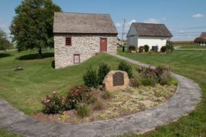
Rieber House – This family farmhouse played a significant role in founding the United Brethren Church in Pennsylvania, likely built around 1750. The Germanic-style home, which sat in a small hollow, was in severe disrepair. Instead of tearing it town, LCSWMA partnered with the Historic Preservation Trust of Lancaster to move the structure—stone by stone—to a new location. LCSWMA then restored the structure and uses it to welcome visitors, as a public meeting space, and to exhibit the Rieber Family story.
Transforming Waste into a Resource
LCSWMA has tackled green energy projects in amazing ways and taken innovative steps to reduce the impact of our community’s waste on the environment. One of the ways they succeed is by extracting the most value from our waste. For example, LCSWMA’s Lancaster Waste-to-Energy Facility combusts waste and creates electricity—enough to power the equivalent of 1 in 5 area homes. The facility also recovers and recycles valuable metals from the post-combusted waste. Additionally, the Lancaster WTE Facility produces steam for the neighboring Perdue Soybean Processing Facility, which is used to power some of their operations instead of fossil fuels.
LCSWMA has also taken the initiative to green its operations. The authority converted its fleet of trash-transfer trucks to run on compressed natural gas (CNG) and provide CNG refueling to area fleets as well. This project reduces over 10 million pounds of air pollutants each year! Additionally, over 2,000 solar panels on four buildings at LCSWMA’s Transfer Station creates enough renewable energy to offset 80% of the site’s annual electric needs.
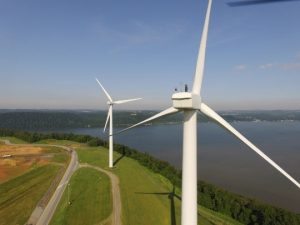
At the Frey Farm Landfill, LCSWMA captures gas from landfilled waste and combusts it to create electricity. Additionally, two GE wind turbines on nonoperational portions of the landfill site generate power for the neighboring Turkey Hill Dairy manufacturing plant. Installed in 2010, the turbines overlook the Susquehanna River, catching the prevailing winds from the northwest. These wind turbines power nearly a quarter of Turkey Hill’s annual electric needs. How much is that in ice cream? About 5-6 million gallons.
These are just some of the projects that LCSWMA has completed along the river in Lancaster County. To see their recreation projects throughout Lancaster and in Dauphin Counties, visit their Waste Give Back – Public Recreation page. Visit www.lcswma.org to learn more or follow LCSWMA on Facebook, Instagram and LinkedIn.
 Chickies Ridge is composed of the uplifted Cambrian Chickies Formation, a mapped bedrock unit in Pennsylvania, New Jersey, and Maryland. It is named for Chickies Rock, a popular rock cliff just north of Columbia along the Susquehanna River. According to the United States Geological Survey (USGS), the summit of the ridge is 587 feet above sea level.
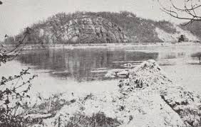


 For those that complete at least 30 activities, you will earn the sticker as well as a voucher for a small ice cream cone at Hinkle’s Restaurant. Hinkle’s will scoop your choice of vanilla or chocolate into a cone or dish. Enjoy it as you walk around town or devour it at their classic Ice Parlor & Soda Fountain.
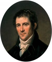 With his uncle’s death in September 1801, Latrobe assumed control of the Pennsylvania portion of the project, working with his Maryland partners. Latrobe surveyed the river in October-November 1801 with the help of two assistant surveyors, chainbearers, axemen and canoemen. He completed his map over the winter, including a proposed new route for navigating the rocky river. Latrobe presented his work to the governor in Lancaster (then Pennsylvania’s capital) in March 1802 and lobbied the legislature for project funding. His efforts were successful, and the navigation improvements were completed soon after.


 COLUMBIA CROSSING RIVER TRAILS CENTER – SNHA manages this riverfront visitor education center in Columbia River Park in Lancaster County for the Borough of Columbia, including visitor services, maps and guides, exhibits, programs, and facility rentals. With Lancaster County entering the
 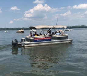 RIVER DISCOVERY BOAT TOURS – SNHA will launch our 2nd season of free pontoon boat tours from the Zimmerman Center on Friday, July 3rd. Tours will be offered Friday/Saturday/Sunday and frequency increased from 3 to 4 per day. Registration will be limited to 8 passengers per tour instead of 10 to allow for social distancing. The boat and equipment will be sanitized between tours. Similar to last year, pre-registration will be required online, but no walk-ons will be permitted to fill no-show seats. All check-in will be done outside in the waterfront pavilion, with Covid-19 screening questions, temperature checks, and face masks required. Disposable masks will be provided to passengers as needed.

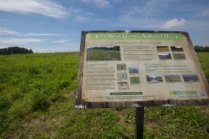 Chestnut Grove Natural Area – Near the Frey Farm Landfill in Manor Township, the Chestnut Grove Natural Area is an impressive restoration project completed by LCSWMA. LCSWMA transformed this previous farmland into a 170-acre nature preserve. This scenic preserve offers 4.5 miles of walking, hiking, and equestrian trails that explore wetlands, grasslands, wildflower meadows, and the River Hills. The area also connects to regional trails including the Turkey Hill Trail and the Enola Low Grade Rail Trail.